
Landslides
| This information has been developed in association with Peter Dahlhaus, University of Ballarat. The term landslide is usually defined as: "the movement of a mass of rock, debris or earth down a slope". This international definition is used by the Australian Geomechanics Society and includes all forms of movement from debris creep to rock falls. The terminology used to describe a landslide depends on the information known about the processes and generally uses two nouns to describe material involved and the style of movement, e.g. a rock fall or a debris flow. The landslide material is classified as either 'bedrock' or 'engineering soil'. Engineering soils are further subdivided into either debris (predominantly sand, gravel, cobbles and boulders) or earth (predominantly silt and clay). The five main types of movement are falls, topples, slides, spreads and flows. | 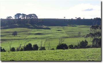 Landslides near Scotts Creek |
Landslides have been a regular event in the natural evolution of landscapes in the Corangamite Region over the past several million years. They occur as one of the principal processes of landscape development. The main function of a landslide is the removal of Earth materials during the formation of valley and coastlines. These processes are still operating in those parts of the region that are being worn down by the actions of streams and rivers, and the eroding coastline.
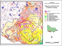 Landslides compared to Simplified Geology |
Over 1 400 landslides have been mapped in various studies within south west Victoria and it is estimated that thousands more, of varying sizes, exist. All mapped landslides occur south of the western Victorian volcanic plain, where the geology, steeper terrain slopes and climate combine to provide the conditions required. Landslides vary in area from a few square metres to over 120 hectares and in volume from a few cubic metres to over ten million cubic metres. They are triggered by prolonged and/or intense rainfall, man-made changes to the landscape and rare earthquake events. The vast majority of landslides occur in two rock types, viz: the Otway Group rocks and the Gellibrand Marl. |

The Otway Group rocks are mostly sandstones and mudstones, made up of fragments of volcanic rocks, calcic feldspars and very little quartz. These minerals that make up the rocks are quickly and easily weathered when exposed to the elements (except quartz), producing a clay-rich soil. The Otway Group is regarded as the most landslide-prone of the geological units in south west Victoria. Landslides occur in both the rock and soil materials, even where the rock is not significantly weathered. Among the other geological units, the Narrawaturk Marl and Gellibrand Marl are also landslide-prone. These marls were deposited in the Otway Basin as the seaway opened up between Antarctica and Australia in the final breakup of Gondwanaland.
© State of Victoria (Agriculture Victoria) 1996 - .

This work, Victorian Resources Online, is licensed under a Creative Commons Attribution 4.0 licence. You are free to re-use the work under that licence, on the condition that you credit the State of Victoria (Agriculture Victoria) as author, indicate if changes were made and comply with the other licence terms.
The licence does not apply to ‘branding’ or some ‘images or photographs’ that may be owned by third parties. We ask you to seek prior approval to use images using the VRO feedback form. Access to higher quality images can also be provided on request.
This page was last updated on .