
GP67
| Location: Nambrok. | Australian Soil Classification: Vertic (& Mottled-Sodic), Eutrophic, Brown CHROMOSOL. |
| Great Soil Group: solodic. | Geology: Mid Pleistocene alluvial plain deposits. |
| General Landscape Description: Upper slope of an old alluvial plain from the mid-Pleistocene era. | Mapping Unit: Wooundellah. |
| Site Description: Grazing paddock. | |
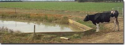 Site GP67 Landscape |
Soil Profile Morphology:
Surface Soil
| A11 | 0-15 cm | Brown (10YR4/3); fine sandy clay loam; weak coarse blocky structure; very firm consistence dry; pH 5.6: | 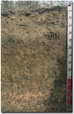 Site GP67 Profile |
| A12 | 15-30 cm | Brown (10YR4/3); sporadically bleached; with rusty root channel mottling; fine sandy clay loam; weak coarse blocky structure; very firm consistence dry; pH 5.9: | |
| A2 | 30-40 cm | Dark yellowish brown (10YR4/4) sporadically bleached; fine sandy clay loam; moderate coarse polyhedral, parting to moderate fine polyhedral structure; very firm consistence dry; pH 5.9: | |
| Subsoil | |||
| B21 | 40-60 cm | Dark yellowish brown (10YR4/4) with dark red (2.5YR4/8) and brownish yellow (10YR6/8) mottles; medium clay; strong coarse polyhedral, parting to strong fine polyhedral structure; shiny faced peds; strong consistence dry; pH 6.1: | |
| B22 | 60-100 cm | Yellowish brown (10YR5/8) with dark yellowish brown (10YR4/4) and slight dark red (2.5YR4/8) mottles; medium clay; moderate coarse prismatic, parting to moderate coarse blocky structure; shiny faced peds; strong consistence dry; many slickensides evident; pH 7.3: | |
| B23 | 100-120 cm | Yellowish brown (10YR5/6); medium clay (sandy); moderate coarse prismatic, parting to moderate coarse blocky structure; dark staining evident; contains few (10%) quartz grit; pH 6.9: | |
| B24 | 120+ cm | Reddish brown (5YR5/4); sandy clay; massive structure; pH 7.7. | |
Key Profile Features:
- Strong texture contrast between surface (A) and subsoil (B21) horizons.
- Vertic properties occur in the deeper subsoil (i.e. slickensides).
Soil Profile Characteristics:
Horizon | pH | Salinity Rating | ||
Surface (A1 horizon) | Moderately Acid | Moderate | Non-Sodic | None1 |
Subsoil (B21 horizon) | Slightly Acid | Very Low | Non-Sodic | None2 |
Deeper subsoil (at 1 m) | Slightly Alkaline | Very Low | Sodic | Slight2 |
2 Moderate dispersion after remoulding.
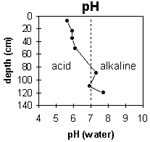 | The surface soil is moderately acid. The upper subsoil is slightly acid becoming slightly alkaline at 1 m depth. | 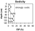 | The surface and upper subsoil is non-sodic becoming sodic at 60 cm depth. |
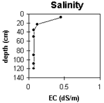 | The surface salinity rating is moderate. The subsoil is very low. | 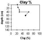 | The clay content increases markedly at the A/B horizon interface |
Horizon | Horizon Depth (cm) | pH (water) | pH (CaCl2) | EC 1:5 | NaCl | Exchangeable Cations | |||
Ca | Mg | K | Na | ||||||
meq/100g | |||||||||
A11 | 0-15 | 5.6 | 5 | 0.45 | <0.03 | 4.9 | 1.5 | 1.4 | 0.1 |
A12 | 15-30 | 5.9 | 5 | 0.12 | 2.6 | 1 | 0.8 | 0.25 | |
A2 | 30-40 | 5.9 | 4.9 | 0.07 | 2 | 1.4 | 0.83 | 0.14 | |
B21 | 40-60 | 6.1 | 5.1 | 0.07 | 3.5 | 5.6 | 1.3 | 0.4 | |
B22 | 60-100 | 7.3 | 6.2 | 0.07 | 2.8 | 7.1 | 0.18 | 1.4 | |
B23 | 100-120 | 6.9 | 5.9 | 0.07 | 3.8 | 9.7 | 0.41 | 1.5 | |
B24 | 120+ | 7.7 | 6.5 | 0.07 | 2.5 | 6.4 | 0.15 | 1.3 | |
Horizon | Horizon Depth (cm) | Exchangeable Aluminium mg/kg | Exchangeable Acidity meq/100g | Field Capacity pF2.5 | Wilting Point pF4.2 | Coarse Sand (0.2-2.0 mm) | Fine Sand (0.02-0.2 mm) | Silt (0.002-0.02 mm) | Clay (<0.002 mm) |
A11 | 0-15 | 16 | 8.7 | 16 | 39 | 20 | 22 | ||
A12 | 15-30 | <10 | 7.7 | 14 | 41 | 231 | 24 | ||
A2 | 30-40 | <10 | 4.8 | 8.7 | 16 | 38 | 19 | 29 | |
B21 | 40-60 | <10 | 9.4 | 20.8 | 8 | 19 | 12 | 62 | |
B22 | 60-100 | 15.8 | 29 | 13 | 10 | 50 | |||
B23 | 100-120 | ||||||||
B24 | 120+ |
Management Considerations:
Whole Profile
- Plant Available Water Capacity (PAWC) is considered to be moderate (estimated at 110 mm) for this soil profile. This is based on an estimated effective rooting depth of 60 cm (i.e. surface soil and upper subsoil). The upper subsoil is well structured (parting to many fine polyhedral shaped peds) which should not restrict root growth as much as some of the more sodic and coarsely structured upper subsoils in the region. The dense and coarsely structured deeper subsoil is likely to restrict rooting depth. Some 50 mm of this estimated PAWC is in the upper two surface horizons (i.e. to 30 cm depth). PAWC has been estimated using a model developed by Littleboy (1995) which uses analytical data for clay%, silt%, fine sand%, coarse sand % and wilting point.
- The level of soluble salts in the surface is moderate and may restrict the growth of salt sensitive species. These levels may be unnaturally high due to the effects of the dry season at the time of sampling (i.e. summer 1997) and are likely to decline following heavy rains and/or irrigation.
- The surface (A1) horizon has a relatively low nutrient holding capacity (based on the sum of the exchangeable calcium, magnesium and potassium cations). Organic matter is important for maintaining soil fertility and aggregation on surface soils such as these with high fine sand and silt contents.
- The surface (A1) horizon is non-sodic but disperses slightly after remoulding. This indicates that tillage or over-stocking of the soil whilst in a moist to wet condition may result in some structural degradation (e.g. surface sealing, exacerbated hardsetting, increased cloddiness) occurring. Raindrop action on bare soil may have a similar effect, so it is important to maintain surface cover.
- The presence of rusty root channel mottling and sporadic bleaching in the subsurface (A2) horizon indicates that periodic waterlogging can occur above the more slowly permeable subsoil.
- The upper subsoil is non-sodic and well structured (parting to many fine polyhedral shaped peds). Root and water movement will therefore not be as restricted as is the case for many of the Sodosols in the region. In the deeper subsoil (i.e. from 60 cm depth) the subsoil becomes sodic and more dense and coarsely structured [and has a low exchangeable calcium to magnesium ratio (0.3)]. As a result, root and water movement will be more restricted in the deeper subsoil.
- Also at 60 cm depth the subsoil displays vertic properties (slickensides). This indicates that significant shrinking and swelling occurs during wetting and drying cycles. This may have some engineering implications (e.g. disruption to fence lines).
© State of Victoria (Agriculture Victoria) 1996 - 2025.

This work, Victorian Resources Online, is licensed under a Creative Commons Attribution 4.0 licence. You are free to re-use the work under that licence, on the condition that you credit the State of Victoria (Agriculture Victoria) as author, indicate if changes were made and comply with the other licence terms.
The licence does not apply to ‘branding’ or some ‘images or photographs’ that may be owned by third parties. We ask you to seek prior approval to use images using the VRO feedback form. Access to higher quality images can also be provided on request.
This page was last updated on 25/01/2019.