
GP63
| Location: Heyfield. | Australian Soil Classification: Vertic, Mesonatric, Brown SODOSOL. |
| Great Soil Group: Solodised solonetz. | Geology: Mid Pleistocene terrace. |
| General Landscape Description: Level plain. | Mapping Unit: Stratford. |
| Site Description: Grazing paddock. | Native Vegetation: Original vegetation included forest red gum (E. tereticornis). |
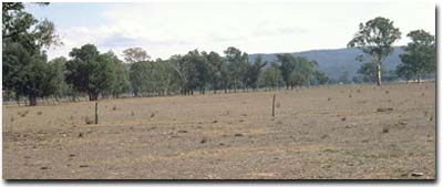 Site GP63 Landscape |
Soil Profile Morphology:
Surface Soil
| A1 | 0-2 cm | Dark brown (10YR3/3); fine sandy loam; pH 5.4; sharp change to: | 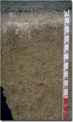 Site GP63 Profile 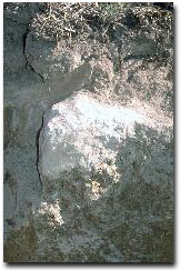 Note: Columnar structure in upper B horizon with associated bleached capping. |
| A21 | 2-10 cm | Yellowish brown (10YR5/4); conspicuously bleached (7.5YR7/2d); fine sandy loam; massive structure; very firm consistence dry; pH 6.0; clear and wavy change to: | |
| A22 | 10-15 cm | Pale Brown (10YR6/3); conspicuously bleached (10YR8/1d); fine sandy loam; massive very firm consistence dry; sharp change to: | |
| Subsoil | |||
| B1 | 15-25cm | Yellowish brown (10YR5/4) with a few (<10%) light yellowish brown (10YR5/8) mottles; light clay; moderate coarse columnar and prismatic, parting to strong coarse blocky structure; strong consistence dry; contains few (2%) sub-rounded manganese segregations (2-6 mm in size) as well as a few (<2%) quartz fragments (2-6 mm in size); pH 6.8; gradual change to: | |
| B21 | 25-50 cm | Yellowish brown (10YR5/6) with a few (<10%) light yellowish brown (10YR5/8) mottles; medium clay; moderate coarse columnar and prismatic, parting to strong coarse blocky structure; strong consistence dry; contains a few (2-5%) sub-rounded manganese segregations (2-6 mm in size); pH 7.2; gradual change to: | |
| B22 | 50-90 cm | Yellowish brown (10YR5/6); medium clay; moderate coarse prismatic, parting to strong coarse blocky structure; very firm consistence moist; contains a few (2%) sub-rounded manganese segregations (2-6 mm in size); pH 7.6; gradual change to: | |
| B23 | 90+ cm | Light olive brown (2.5Y5/6); light clay; some lenticular structure and slickensides evident; very firm consistence moist; pH 7.9. |
- Strong texture contrast between surface (A) horizons and upper subsoil (B21) horizon.
- Conspicuously bleached subsurface (A2) horizons.
- Columnar structure in upper subsoil.
- Vertic properties present within the deeper subsoil (i.e. slickensides and lenticular structure).
Horizon | pH | Salinity Rating | ||
Surface (A1 horizon) | Strongly Acid | Moderate | Non-sodic | None |
Subsoil (B21 horizon) | Slightly Alkaline | Low | Strongly Sodic | Complete |
Deeper subsoil (at 90 cm) | Slightly Alkaline | Moderate | Strongly Sodic | Complete |
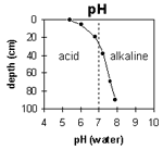 | The surface soil is strongly acid. The subsoil is slightly alkaline. | 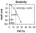 | The surface soil is non-sodic. he subsoil is strongly sodic throughout. |
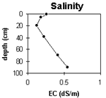 | The surface salinity rating is moderate. The subsoil rating is low becoming moderate at depth. | 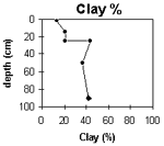 | The clay content increases sharply at 25 cm depth. |
Horizon | Horizon Depth (cm) | pH (water) | pH (CaCl2) | EC 1:5 | NaCl | Exchangeable Cations | |||
Ca | Mg | K | Na | ||||||
meq/100g | |||||||||
A1 | 0-2 | 5.4 | 4.8 | 0.26 | <0.03 | 9.3 | 1.9 | 0.7 | 0.2 |
A21 | 2-10 | 6 | 5.3 | 0.18 | 4.7 | 1 | 0.17 | 0.51 | |
A22 | 10-15 | ||||||||
B1 | 15-25 | 6.8 | 5.9 | 0.12 | 2.8 | 3 | 0.11 | .073 | |
B21 | 25-50 | 7.2 | 6.3 | 0.22 | 3 | 7.9 | 0.2 | 2 | |
B22 | 50-90 | 7.6 | 6.7 | 0.41 | 0.08 | 0.9 | 7 | 0.2 | 2.7 |
B23 | 90+ | 7.9 | 7.1 | 0.55 | 0.1 | 0.8 | 8 | 0.2 | 3.4 |
Horizon | Horizon Depth (cm) | Exchangeable Aluminium mg/kg | Exchangeable Acidity meq/100g | Field Capacity pF2.5 | Wilting Point pF4.2 | Coarse Sand (0.2-2.0 mm) | Fine Sand (0.02-0.2 mm) | Silt (0.002-0.02 mm) | Clay (<0.002 mm) |
A1 | 0-2 | <10 | 12 | 13.2 | |||||
A21 | 2-10 | <10 | 3.1 | 5.7 | 7 | 41 | 34 | 13 | |
A22 | 10-15 | ||||||||
B1 | 15-25 | 6.9 | 9 | 37 | 32 | 21 | |||
B21 | 25-50 | 15.2 | 6 | 23 | 27 | 44 | |||
B22 | 50-90 | 13 | 8 | 29 | 27 | 37 | |||
B23 | 90+ | 14.8 | 4 | 23 | 30 | 42 |
Management Considerations:
Whole Profile
- Plant Available Water Capacity (PAWC) is considered to be very low (estimated at 20 mm) for this soil profile. This is based on an estimated effective rooting depth of 15 cm (i.e. surface horizons). The dense and coarsely structured upper subsoil is likely to significantly restrict rooting depth. PAWC has been estimated using a model developed by Littleboy (1995) which uses analytical data for clay %, silt %, fine sand %, coarse sand % and wilting point.
- The shallow surface soil is strongly acid. This indicates that aluminium and manganese toxicity could occur. However, the level of exchangeable aluminium measured for this pit site is quite low (<10 mg/kg) and unlikely to restrict the growth of aluminium sensitive species. Lime can be used to increase soil pH but it should be noted that a pH/aluminium test is best performed from samples taken across the paddock and bulked together. Other factors also need to be considered before lime is recommended (e.g. pasture species grown, method of application, local trial responses, soil surface structure and likely cost/benefit).
- Deficiencies in molybdenum and phosphorus may occur in the strongly acid surface soil. Manganese toxicity may also occur particularly when poorly drained (as waterlogging may bring manganese into solution).
- The surface (A1) horizon has a moderate nutrient holding capacity (based on the sum of the exchangeable calcium, magnesium and potassium cations). Organic matter is important for enhancing soil fertility, water holding capacity and soil structural condition. This is important at this site where only a shallow surface horizon overlays a bleached subsurface horizon of low fertility.
- The presence of bleaching in the subsurface (A2) horizon indicates that periodic waterlogging occurs above the more slowly permeable subsoil. This horizon will become ‘spewy’ when waterlogged.
The dense and coarsely structured upper subsoil is strongly sodic and has a low calcium to magnesium ratio (0.4). Complete dispersion occurs as a result, and root and water movement is likely to be significantly restricted. The upper subsoil also has coarse columnar structure, which will provide a physical barrier to root movement. Deep ripping with gypsum application, has been advocated by some researchers as an effective ameliorating technique for sodic subsoils. However, the use of gypsum may not be economically viable. Any deep ripping should not be carried out when the subsoil is in a moist to wet condition.
- The presence of mottling throughout the subsoil indicates imperfect drainage.
- The level of soluble salts below 90 cm depth becomes moderate but is only likely to affect deep rooted salt sensitive species.
- The deeper subsoil displays vertic properties (i.e. slickensides and lenticular structure). This indicates that significant shrinking and swelling occurs during wetting and drying cycles. This may have some engineering implications (e.g. disturbance to fence lines).
© State of Victoria (Agriculture Victoria) 1996 - 2025.

This work, Victorian Resources Online, is licensed under a Creative Commons Attribution 4.0 licence. You are free to re-use the work under that licence, on the condition that you credit the State of Victoria (Agriculture Victoria) as author, indicate if changes were made and comply with the other licence terms.
The licence does not apply to ‘branding’ or some ‘images or photographs’ that may be owned by third parties. We ask you to seek prior approval to use images using the VRO feedback form. Access to higher quality images can also be provided on request.
This page was last updated on 25/01/2019.