
9. Albert River Estuary
|
This information has been developed from the publications:
|
| Location: | 705205 to 710250. | 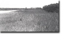 Rice-grass (Spartina townsendii) and white mangrove (Avicennia marina) on inter-tidal flats - Albert River estuary. |
Access: | Old Settlement Beach road; boat from Port Albert. | |
Ownership: | Mainly private land. | |
Geology/Geomorphology: | The Albert River is incised into a coastal terrace between Port Albert and Alberton to form an estuary approximately eight kilometres long. The lower section consists of a broad meandering channel bordered by mangroves, spartina and salt marsh. These salt tolerant plants give way to brackish and fresh water reed and paper bark swamp species as tidal influence decreases along the estuary. The broad, sweeping meanders of the tidal section contrast with the smaller, tighter river meander bends upstream from Alberton. The lower section of the estuary is a wide embayment which cuts across the older barrier dunes. The margin of the estuary is a steep cliff which exposes buried soil horizons in this dune material. | |
Significance: | Regional. This is the largest estuary in the study area and contains a diverse salt marsh community including Spartina townsendii. The contrast in meander form is of particular interest. | |
Management: | Dredging of the meandering section of the estuary would increase the tidal flow and probably lead to erosion of the channel banks. Detailed study of the need for, and the impact of deepening the channel should precede any such activity. | |
References: | Jenkin, J.J. 1968. The geomorphology and upper Cainozoic geology of south-east Gippsland, Victoria. Mem. geol. Surv. Vict., 27. | |
© State of Victoria (Agriculture Victoria) 1996 - 2025.

This work, Victorian Resources Online, is licensed under a Creative Commons Attribution 4.0 licence. You are free to re-use the work under that licence, on the condition that you credit the State of Victoria (Agriculture Victoria) as author, indicate if changes were made and comply with the other licence terms.
The licence does not apply to ‘branding’ or some ‘images or photographs’ that may be owned by third parties. We ask you to seek prior approval to use images using the VRO feedback form. Access to higher quality images can also be provided on request.
This page was last updated on 25/01/2019.