
7. Dunes, Marsh, Beaches - Gellions Run
|
This information has been developed from the publications:
|
| Location: | 680195 to 700205. South-eastern shoreline of Gellions Run. | 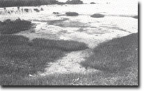 Sand cheniers and spits replacing mangroves on tidal flats - eastern end of Gellions Run. |
Access: | Unformed tracks off Old Welshpool Road in Gellions Run. | |
Ownership: | Crown Land. | |
Geology/Geomorphology: | Gellions Run is a complex of eroded older barrier dunes with inter-dune swamps and shallow or dry lakes. The south-eastern shoreline (facing Midge Channel) is fringed by a wide saltmarsh and mangrove zone but this is being modified by erosion and sand deposition by tidal flow in the estuary of the Albert River. In the site selected, a high dune ridge is representative of the older barrier terrain. In front of this is a wide marsh which shows distinct vegetation zonation – Melaleuca ericifolia, Juncus maritimus, Arthrocnemum and Salicornia marsh with Avicennia marina on the seaward edge. North-east – towards the Albert estuary – the marsh has been eroded in places and mangroves are being buried by sand spits and cheniers moved by tidal currents and wave action at high tide. | |
Significance: | Regional. The site displays a clear and little modified example of the older barrier terrain. The dynamics of the salt marsh-mangrove zone are typical of the changes that are taking place in the tidal inlets where sand is mobilised by tides and wave action. | |
Management: | To avoid disturbance to the dune terrain, clearing of scrub or road building should not be permitted at this site. | |
© State of Victoria (Agriculture Victoria) 1996 - 2025.

This work, Victorian Resources Online, is licensed under a Creative Commons Attribution 4.0 licence. You are free to re-use the work under that licence, on the condition that you credit the State of Victoria (Agriculture Victoria) as author, indicate if changes were made and comply with the other licence terms.
The licence does not apply to ‘branding’ or some ‘images or photographs’ that may be owned by third parties. We ask you to seek prior approval to use images using the VRO feedback form. Access to higher quality images can also be provided on request.
This page was last updated on 25/01/2019.