13. Hedley Swamp
|
This information has been developed from the publications:
|
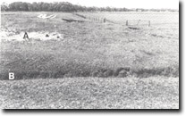
| Location: | 610210. Four kilometres south-east of Hedley. |  "Lunette" ridge on the eastern side of a drained peat swamp. Sand, (A), overlies silt and peat, (B). Hedley Swamp, Gelliondale. |
Access: | Telegraph Road; Rossiters Road. | |
Ownership: | Mainly private land. | |
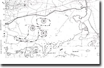
Geology/Geomorphology: | Of major significance here is a broad, drained swamp enclosed by low barrier dunes. The swamp has an outlet towards the south-west that probably represents a former tidal inlet into the swamp basin. A well defined, acurate, “lunette” ridge lies on the eastern edge of the basin and includes coarse and fine sand, silt and peat. The ridge indicates a complex history of filling and drying of the lake basin, with sand and desiccated organic material being blown from the surface during arid periods. | |
Significance: | State. The “lunette” ridge is the largest of several in the Welshpool-Alberton area. It is well preserved and compares in both form and dimension with small lunettes in northern and north-western Victoria. This ridge is a composite feature and includes beach material as well as deflated silts and organic matter. The detailed stratigraphy of the ridge has not been investigated, and further investigation here could add to the understanding of late Pleistocene climates and sea level changes in South Gippsland. | |
Management: | The “lunette” ridge would be destroyed by extensive quarrying. It is recommended that no major removal of sand materials be permitted and existing vegetation be retained to avoid further wind erosion. | |


