
46. Thomson River - Cowarr
|
This information has been developed from the publications:
|
| Location: | 735925 to 768925. | 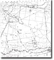 Sites 8221-43 to 46 |
Access: | Traralgon – Maffra Road. | |
Ownership: | Mainly Crown Land. | |
Geology/Geomorphology: | The river is bordered by low bluffs and cliffs cut in alluvium. The channel is wide, and gravel bars develop minor braided reaches at low flow. Bank erosion is evident along both sides of the stream and extensive erosion control measures have been implemented. | |
Significance: | Regional. The broad meander form and the braided and gravelly nature of the channel is typical of flood plains in Central Gippsland. The apparent success of erosion control measures is of particular interest. | |
Management: | Removal of gravel from the river channel should be prohibited and access fords across the river should be limited to sustain the effect of erosion control procedures already implemented. | |
© State of Victoria (Agriculture Victoria) 1996 - .

This work, Victorian Resources Online, is licensed under a Creative Commons Attribution 4.0 licence. You are free to re-use the work under that licence, on the condition that you credit the State of Victoria (Agriculture Victoria) as author, indicate if changes were made and comply with the other licence terms.
The licence does not apply to ‘branding’ or some ‘images or photographs’ that may be owned by third parties. We ask you to seek prior approval to use images using the VRO feedback form. Access to higher quality images can also be provided on request.
This page was last updated on .