
45. Haunted Hill Gravels - Cowarr
|
This information has been developed from the publications:
|
| Location: | 745914. Two kilometres south-east of Cowwarr. | 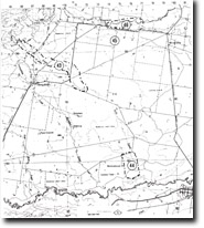 Sites 8221-43 to 46 |
Access: | Traralgon-Maffra Road. | |
Ownership: | Private Land. | |
Geology/Geomorphology: | A small quarry on the degraded bluff bordering the Thomson River plain exposes a coarse gravel facies of the Haunted Hill Gravels. An abandoned meander occurs on the river terrace below the bluff. | |
Significance: | Local. Of particular interest is the coarse gravel material which also demonstrates that the slope is a former erosional valley side bluff ratehr than a depositional terrace. The abandoned channel lies on such a terrace at a lower level hence illustrating several phases of development of the Thomson River flood plain. | |
Management: | Further quarrying of the old bluff would maintain the gravel exposures and would enhance the value of the site. | |
© State of Victoria (Agriculture Victoria) 1996 - .

This work, Victorian Resources Online, is licensed under a Creative Commons Attribution 4.0 licence. You are free to re-use the work under that licence, on the condition that you credit the State of Victoria (Agriculture Victoria) as author, indicate if changes were made and comply with the other licence terms.
The licence does not apply to ‘branding’ or some ‘images or photographs’ that may be owned by third parties. We ask you to seek prior approval to use images using the VRO feedback form. Access to higher quality images can also be provided on request.
This page was last updated on .