44. Fells Creek - "Ravenswood"
|
This information has been developed from the publications:
|
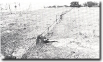
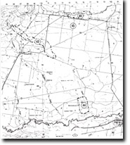
| Location: | 760800. Fells Creek between Cairnbrook Road bridge and La Trobe River, six kilometres north-west of Rosedale. |  Fenceposts buried by flood fans of Fells Creek, "Ravenswood". |
Access: | Cairnbrook and Lower Cairnbrook Roads. | |
Ownership: | Private land. | |
Geology/Geomorphology: | In recent years, erosion on Fells Creek has extended upstream from the Cairnbrook Road bridge causing deepening and widening of the channel. Sediment removed from here has been deposited downstream to partly block both the channel and an artificial drain, and has partly buried fence posts on the “Ravenswood” property. | |
Significance: | Regional. The cause of the rapid and recent erosion is not clear. Similar gully development has been noted on the upper reaches of Fells Creek, on Eaglehawk Creek, and on several of the southern tributaries of the La Trobe River. | |
Management: | Because extension of the gullying is causing damage to public and private property, management to alleviate this is the major consideration at this site. | |
References: | Bird, E.C.F., Bird, J.F., Finlayson, B.L., McArthur, J.A. and Mckay, J.M. 1979. Bank Erosion on the Latrobe River and its Lower Tributaries. Publication No. 267, Environmental Studies Series, Ministry for Conservation, Victoria. | |


