
42. Eaglehawk Creek Gully and "Delta"
|
This information has been developed from the publications:
|
| Location: | 618852 to 635805. Eaglehawk Creek north and south of the Traralgon – Maffra Road bridge. | 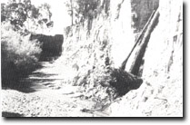 Gullied section of Eaglehawk Creek. |
Access: | Traralgon-Maffra Road. | |
Ownership: | Private Land and Crown Land. | |
Geology/Geomorphology: | Eaglehawk Creek is deeply gullied along this sector, the gullies attaining depths of 10 metres near the junction with Stony Creek. The gullied sector extends for five kilometres from the Eaglehawk Creek ford downstream to the Traralgon Road bridge. The rapid erosional phase dates from the 1890’s following diversion of 2 tributary streams which increased the discharge in Eaglehawk Creek. Below here is a dispositional tract (known locally as the “Delta”) where the gravels and sands are spread over the flood plain. Flooding in this sector is a recurrent problem and dredging and straightening of the channel has been undertaken. | |
Significance: | State. This site is a classic illustration of rapid adjustment to channel morphology resulting from changes in the hydrological regime. | |
Management: | The site presents a case study in river management and strategies should be developed to alleviate the flooding and gullying problems. | |
References: | Bird, E.C.F., Bird, J.F., Finlayson, B.L., McArthur, J.A. and Mckay, J.M. 1979. Bank Erosion on the Latrobe River and its Lower Tributaries. Publication No. 267, Environmental Studies Series, Ministry for Conservation, Victoria. | |
Sites 8221-40 41 42
© State of Victoria (Agriculture Victoria) 1996 - .

This work, Victorian Resources Online, is licensed under a Creative Commons Attribution 4.0 licence. You are free to re-use the work under that licence, on the condition that you credit the State of Victoria (Agriculture Victoria) as author, indicate if changes were made and comply with the other licence terms.
The licence does not apply to ‘branding’ or some ‘images or photographs’ that may be owned by third parties. We ask you to seek prior approval to use images using the VRO feedback form. Access to higher quality images can also be provided on request.
This page was last updated on .