
37. Flynns Creek
|
This information has been developed from the publications:
|
| Location: | 733733. Three kilometres south of the Princes Highway. | 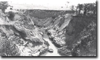 Flynns Creek downstream from Stuckeys bridge. |
Access: | Flynns Creek Road. | |
Ownership: | Private land. | |
Geology/Geomorphology: | Flynns Creek is deeply gullied for a distance of three kilometres upstream from the railway bridge, the gully depth increasing to 5 to 8 metres at Stuckeys Land. Erosion here caused a bridge to collapse in 1950. Erosion control measures at the site have prevented further headward erosion on this gully. | |
Significance: | Regional. The reason for the onset of gullying is not clear and presents an important research topic. The area illustrates a relatively inexpensive but effective means of gully control. | |
Management: | No further control works should be implemented until research is undertaken to determine the causes of the onset of gully erosion. | |
References: | Bird, E.C.F., Bird, J.F., Finlayson, B.L., McArthur, J.A. and Mckay, J.M. 1979. Bank Erosion on the Latrobe River and its Lower Tributaries. Publication No. 267, Environmental Studies Series, Ministry for Conservation, Victoria. | |
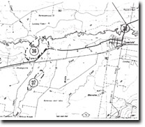
Sites 8221 - 36 37 38
© State of Victoria (Agriculture Victoria) 1996 - .

This work, Victorian Resources Online, is licensed under a Creative Commons Attribution 4.0 licence. You are free to re-use the work under that licence, on the condition that you credit the State of Victoria (Agriculture Victoria) as author, indicate if changes were made and comply with the other licence terms.
The licence does not apply to ‘branding’ or some ‘images or photographs’ that may be owned by third parties. We ask you to seek prior approval to use images using the VRO feedback form. Access to higher quality images can also be provided on request.
This page was last updated on .