
35. Traralgon Creek Terraces - Traralgon
|
This information has been developed from the publications:
|
| Location: | 595685. Three to four kilometres south of Traralgon. | |
Access: | Traralgon Creek Road | |
Ownership: | Private Land. | |
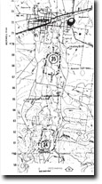
Geology/Geomorphology: | Four sets of river terraces are developed along the Traralgon Creek. The complete sequence is best displayed on the eastern side of the valley. A well defined bluff marks the limit of the flood plain on the west of the creek. | |
Significance: | Local. This is a clear display of confined flood plain features including bluffs, meanders, cut-offs, and terraces. | |
Management: | Artificial straightening of the channel and drainage of the cut-off meanders should be prohibited. Land use that would obscure the form of the terraces, particularly the step that connects two terrace levels, should be prohibited. | |
© State of Victoria (Agriculture Victoria) 1996 - .

This work, Victorian Resources Online, is licensed under a Creative Commons Attribution 4.0 licence. You are free to re-use the work under that licence, on the condition that you credit the State of Victoria (Agriculture Victoria) as author, indicate if changes were made and comply with the other licence terms.
The licence does not apply to ‘branding’ or some ‘images or photographs’ that may be owned by third parties. We ask you to seek prior approval to use images using the VRO feedback form. Access to higher quality images can also be provided on request.
This page was last updated on .