
22. Yarram Formation Quarry
|
This information has been developed from the publications:
|
| Location: | 650475. Four kilometres east of Balook. | 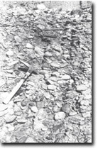 Cemented pebble conglomerate - Blackwarry Road quarry. |
Access: | Adjacent to Grand Ridge Road. | |
Ownership: | Crown Land. | |
Geology/Geomorphology: | A quarry face exposes pebble beds of the Palaeocene Yarram Formation to a maximum of 20 metres vertically. | |
Significance: | State. The site represents the only complete section exposed within the state of the Yarram formation. | |
Management: | Maintenance of clear exposures within the quarry will maintain the significance of the site. | |
Sites 8221-21 22 23
© State of Victoria (Agriculture Victoria) 1996 - .

This work, Victorian Resources Online, is licensed under a Creative Commons Attribution 4.0 licence. You are free to re-use the work under that licence, on the condition that you credit the State of Victoria (Agriculture Victoria) as author, indicate if changes were made and comply with the other licence terms.
The licence does not apply to ‘branding’ or some ‘images or photographs’ that may be owned by third parties. We ask you to seek prior approval to use images using the VRO feedback form. Access to higher quality images can also be provided on request.
This page was last updated on .