
15. Yarram - Traralgon Road Cutting
|
This information has been developed from the publications:
|
| Location: | 786530. Three kilometres north of Carrajung Lower. | 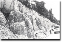 Lignite band, (arrowed), in Traralgon Formation. |
Access: | Yarram-Traralgon Road. | |
Ownership: | Crown Land. | |
Geology/Geomorphology: | The road cutting exposes a five metre section of the Eocene Traralgon Formation. The section is a fine clayey sand and contains a thin band of brown coal. | |
Significance: | Regional. This is one of the few clear exposures of the Traralgon Formation available. It is of interest for the exposure of the thin brown coal band, as sub-surface this formation includes the thick coal seams of the Stradbroke coalfield. | |
Management: | Maintenance of clear faces in the road cutting is necessary. | |
Sites 8221 - 12 to 16
© State of Victoria (Agriculture Victoria) 1996 - .

This work, Victorian Resources Online, is licensed under a Creative Commons Attribution 4.0 licence. You are free to re-use the work under that licence, on the condition that you credit the State of Victoria (Agriculture Victoria) as author, indicate if changes were made and comply with the other licence terms.
The licence does not apply to ‘branding’ or some ‘images or photographs’ that may be owned by third parties. We ask you to seek prior approval to use images using the VRO feedback form. Access to higher quality images can also be provided on request.
This page was last updated on .