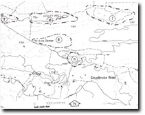
10. Holey Hill
|
This information has been developed from the publications:
|
| Location: | 945685. Fourteen kilometres south-east of Rosedale. |  Sites 8221 - 7 to 11 |
Access: | Holey Hill Track off Limestone Quarry Road. | |
Ownership: | Crown Land (Holey Plains State Park). | |
Geology/Geomorphology: | Holey Hills is a narrow ridge trending east-north-east along the crest of the Baragwanath Anticline and is the most prominent of several ridges on the Holey Plains north of Merriman Creek. The topography here is of complex origin. The trend of the main ridges and drainage lines has been determined partly by tilting and erosion on the southern flank of the Baragwanath Anticline, and partly by deflation and aeolion deposition. | |
Significance: | Regional. The form and composition of the Holey Hill ridge of this site. Clear exposures of the material comprising the ridge would illustrate the complexity of origin of the relief. | |
Management: | Limited quarrying is compatible with maintaining the significance of this site. Clear exposures of the material comprising the ridge would illustrate the complexity of origin of the relief. | |
References: | Jenkin, J.J. 1968. The geomorphology and upper Cainozoic geology of south-east Gippsland, victoria. Mem. geol. Surv. Vict., 27. | |


