
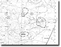
1 to 5. High Level Swamps on Tertiary Sandstones and Sands
Site 1 | Site 2 | Site 3 | Site 4 | Site 5
This information has been developed from the publications:
|
| Introduction: | Between Stradbroke and Gormandale are numerous small lakes and swamps, the largest being Kangaroo Swamp which is over 1, 000 metres long and 600 metres wide. Some of the lake basins lie on drainage lines which have been blocked either by minor slumping or by accumulation of wind-blown sand. Others, particularly the larger basins, are probably deflation hollows where broad valleys have been enlarged by wind action during Pleistocene arid climatic phases. Of notable interest are those basins which are 'higher level' - i.e. they lie on low, broad divides rather than on the valley floors. | |
1. | ||
Location: | 852596. Eight kilometres south of Willung. | |
Access: | Old Rosedale Road. | |
Ownership: | Crown Land. | |
Significance: | Five groups of lakes or swamps selected as being of regional significance are identified. However, no geomorphological analysis has been undertaken and the details of the origin and ages of lake basins are unknown. The wetlands in this area constitute the largest group of relatively undisturbed freshwater lakes and swamps in the Central Gippsland study area. | |
Management: | The importance of all wetland areas is decreased once they have been subjected to drainage, grazing, filling or if there is intensive clearing and/or erosion within their catchments. It is therefore recommended that the sites listed as 8221-1, 8221-2, 8221-3, 8221-4 and 8221–5 inclusive should not be subject to these disturbances. Planning of future coal-extraction operations should take account of the geomorphological and botanical significance of these wetlands. | |
2. | ||
Location: | 860585. Nine kilometres south of Willung. | |
Access: | Old Rosedale Road. | |
Ownership: | Crown Land. | |
Significance: | Five groups of lakes or swamps selected as being of regional significance are identified. However, no geomorphological analysis has been undertaken and the details of the origin and ages of lake basins are unknown. The wetlands in this area constitute the largest group of relatively undisturbed freshwater lakes and swamps in the Central Gippsland study area. | |
Management: | The importance of all wetland areas is decreased once they have been subjected to drainage, grazing, filling or if there is intensive clearing and/or erosion within their catchments. It is therefore recommended that the sites listed as 8221 – 1, 8221-2, 8221-3, 8221-4 and 8221–5 inclusive should not be subject to these disturbances. Planning of future coal-extraction operations should take account of the geomorphological and botanical significance of these wetlands. | |
Page top
3. | ||
Location: | 900535. | 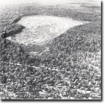 Kangaroo Swamp. |
Access: | Harraps Highway and Kangaroo Swamp Road. | |
Ownership: | Mainly private land. | |
Significance: | Five groups of lakes or swamps selected as being of regional significance are identified. However, no geomorphological analysis has been undertaken and the details of the origin and ages of lake basins are unknown. The wetlands in this area constitute the largest group of relatively undisturbed freshwater lakes and swamps in the Central Gippsland study area. | |
Management: | The importance of all wetland areas is decreased once they have been subjected to drainage, grazing, filling or if there is intensive clearing and/or erosion within their catchments. It is therefore recommended that the sites listed as 8221–1, 8221-2, 8221-3, 8221-4 and 8221– 5 inclusive should not be subject to these disturbances. Planning of future coal-extraction operations should take account of the geomorphological and botanical significance of these wetlands. | |
Page top
4. | ||
Location: | 930600. Ten kilometres west of Stradbroke. | 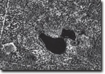 Swamps and lakes west of Stradbroke. © Crown (State if Victoria) Copyright. reproduced by permission of the Surveyor-General, Victoria. |
Access: | Thirteen Mile Road and North-South Road. | |
Ownership: | Crown Land. | |
Significance: | Five groups of lakes or swamps selected as being of regional significance are identified. However, no geomorphological analysis has been undertaken and the details of the origin and ages of lake basins are unknown. The wetlands in this area constitute the largest group of relatively undisturbed freshwater lakes and swamps in the Central Gippsland study area. | |
Management: | The importance of all wetland areas is decreased once they have been subjected to drainage, grazing, filling or if there is intensive clearing and/or erosion within their catchments. It is therefore recommended that the sites listed as 8221-1, 8221-2, 8221-3, 8221-4 and 8221–5 inclusive should not be subject to these disturbances. Planning of future coal-extraction operations should take account of the geomorphological and botanical significance of these wetlands. | |
Page top
5. | ||
Location: | 910605 to 900590. 12 kilometres west of Stradbroke. | 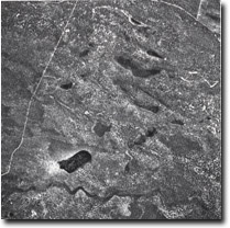 Swampl complex, west of Stradbroke. © Crown (State if Victoria) Copyright. reproduced by permission of the Surveyor-General, Victoria. |
Access: | Harraps Highway. | |
Ownership: | Crown Land. | |
Significance: | This area contains a number of small lakes, some with alignments oblique to the trend of the major dune ridges, (see 8221– 1). | |
Management: | This area contains a number of small lakes, some with alignments oblique to the trend of the major dune ridges, (see 8221– 1). | |
© State of Victoria (Agriculture Victoria) 1996 - .

This work, Victorian Resources Online, is licensed under a Creative Commons Attribution 4.0 licence. You are free to re-use the work under that licence, on the condition that you credit the State of Victoria (Agriculture Victoria) as author, indicate if changes were made and comply with the other licence terms.
The licence does not apply to ‘branding’ or some ‘images or photographs’ that may be owned by third parties. We ask you to seek prior approval to use images using the VRO feedback form. Access to higher quality images can also be provided on request.
This page was last updated on .