
25. Morwell River - Yinnar
|
This information has been developed from the publications:
|
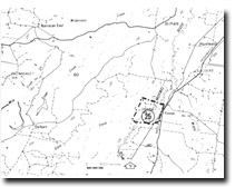
| Location: | 404575. Morwell River flood plain 0.5 to one kilometre south of Yinnar. | |
Access: | Midland Highway, Yinnar. | |
Ownership: | Private Land. | |
Geology/Geomorphology: | A district levee borders the Morwell River at Yinnar and a backswamp is contained between this levee and the valley-side bluffs. | |
Significance: | Regional. Such distinct levee and backswamp development is unusual in Central Gippsland streams. Well developed levees and backswamps were a characteristic feature of the Morwell River flood plain before the major diversion works in the Hazelwood area. This section at Yinnar is one of the few remaining undisturbed levee backswamp bluff landform units on the river. | |
Management: | Major river diversion works here would destroy the site. Future diversion projects should attempt to retain the landform units along at least several hundred metres of the flood plain. | |
© State of Victoria (Agriculture Victoria) 1996 - 2025.

This work, Victorian Resources Online, is licensed under a Creative Commons Attribution 4.0 licence. You are free to re-use the work under that licence, on the condition that you credit the State of Victoria (Agriculture Victoria) as author, indicate if changes were made and comply with the other licence terms.
The licence does not apply to ‘branding’ or some ‘images or photographs’ that may be owned by third parties. We ask you to seek prior approval to use images using the VRO feedback form. Access to higher quality images can also be provided on request.
This page was last updated on 25/01/2019.