
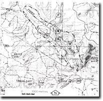
20. Tyers River Flood Plain
|
This information has been developed from the publications:
|
| Location: | 515772. Tyers River floodplain at Tyers West. | |
Access: | Tyers Road from Yallourn North. | |
Ownership: | Private Land. | |
Geology/Geomorphology: | River terraces and abandoned meander scars occur on the floodplain of the Tyers River. | |
Significance: | Local. These features are typical examples of the floodplain morphology of the smaller tributaries of the La Trobe River east of Yallourn. | |
Management: | Land uses seriously affected by flooding should be prohibited from the lower terrace. Limited quarrying of the upper terrace is compatible with the maintenance of the site as this would provide geological profiles of the terrace materials. | |
© State of Victoria (Agriculture Victoria) 1996 - 2025.

This work, Victorian Resources Online, is licensed under a Creative Commons Attribution 4.0 licence. You are free to re-use the work under that licence, on the condition that you credit the State of Victoria (Agriculture Victoria) as author, indicate if changes were made and comply with the other licence terms.
The licence does not apply to ‘branding’ or some ‘images or photographs’ that may be owned by third parties. We ask you to seek prior approval to use images using the VRO feedback form. Access to higher quality images can also be provided on request.
This page was last updated on 25/01/2019.