19. Tyers River
|
This information has been developed from the publications:
|
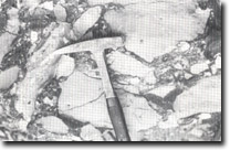
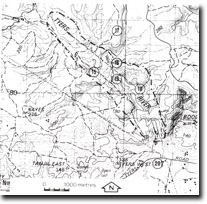
| Location: | 494806. Approximately five kilometres south-east of Moondarra reservoir. |  Chert conglomerate - Tyers River. |
Access: | La Trobe Valley Waterworks and Sewerage Road via Boola Road. | |
Ownership: | Crown Land. | |
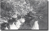
Geology/Geomorphology: | Coopers Creek Limestone, together with mudstones and grits of the Boola Formation are well exposed in low river side cliffs at this locality. A typical section through the sedimentary sequence shows chert-pebble mudstone of the Boola Formation which grades into a conglomerate cemented with carbonate. Further east, the quantity of chert pebbles decreases and the rock grades into a coarse calcarenitic limestone. The lower limestone beds are graded, varying from a coarse calcarenite composed of colonial corals and large crinoid ossicles through to fine calcilutite. This well bedded sequence passes upward into more thickly bedded, massive limestone with no grading apparent within the units. The limestones are highly fossilferous in parts and include occasional fragmentary sponges, and more commonly stromatoporoids, tabulate and rugose corals. Gastropods are generally rare in the Coopers Creek Limestone; however, large specimens (up to 18 cm) of Loxonema and Scalaetrochus type gastropods occur in a massive limestone bed. Brachiopods, lamellibranchs, gastropods, pheropods and trilobites are fairly common in the Boola Formation of the area. For a detailed account of the fossil fauna see Philip (1962). At several localities within this state, limestone outcrops in cliffs immediately adjacent to the stream. These cliffs show several solution features, the most prominent of which are solution notches located just above lower water discharge height. | |
Significance: | State. The limestone outcrops associated with the valley of the Tyers River are the only known exposures of this limestone sequence in the state. | |
Management: | Most of the best exposures occur at or near river level in underside cliffs. Consequently, further damming of the Tyers River downstream from the Boola Road crossing would flood the exposures and should therefore be prohibited. | |
References: | Philip,G.M. 1962. The Jurassic sediments of the Tyers Group, gippsland, Victoria. Proc. R. Soc. Vict., 70, pp. 181-199. VandenBerg, A.H.M. 1975. Definitions and description of middle Ordovician to middle Devonian rock units of the Warburton district, East Central Victoria. Rep. geol. Surv. Vict., 1975/6. | |
 Solution notches in Boola Formation limestone - Tyers River. |


