
18. Tyers River Gorge
|
This information has been developed from the publications:
|
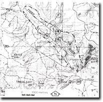
| Location: | 515782 to 473824. Tyers River Valley, including the Boola and Tyers Quarries and Petersons Lookout. | 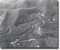 Tyers River gorge below Moondarra Reservoir. |
Access: | Blair Road, Boola Road, Western extension of Rintouls Creek Road. | |
Ownership: | Crown Land. | |
Geology/Geomorphology: | The Tyers River has incised a deep valley south of Mondarra Reservoir which is characterised by entrenched meanders and gorge sections. The latter are particularly prominent in the southern sections of the site where cliffs of greater than 100 metres in height have been cut in Cretaceous sediments (Petersons Lookout). The site includes the type area for the Cretaceous Strzelecki Group and several important exposures of the Boola Formation and Coopers Creek Limestone. The latter sediments are well exposed in both the Boola and Tyers Quarries. Fossils derived from sediments outcropping in this site have been used to define the stratigraphic position of the various formations occurring in the area. | |
Significance: | State. The Tyers river gorge provides important sections in the Lower Devonian and Cretaceous sediments in an area of relatively poor outcrop. Fossil records collected from these outcrops are used in stratigraphic determinations while the gorge morphology of the river valley is distinctive when compared with the other rivers of Central Victoria. | |
Management: | The construction of additional water storage below Moondarra Reservoir would obscure exposures and destroy this important site and this use should be prohibited. Boola and Tyers quarry are abandoned and beginning to degrade. Limited excavation, or grading of the quarry faces would maintain the exposures and enhance the value of the localities. Extension of roads or limited extension of quarrying within the site is consistent with the maintenance of the site significance. | |
References: | Philip,G.M. 1962. The Jurassic sediments of the Tyers Group, gippsland, Victoria. Proc. R. Soc. Vict., 70, pp. 181-199. Douglas, J.G. 1969. The Mesozoic floras of Victoria, Parts 1 and 2. Mem. Geol. Surv., 28. Cooper, B.J. 1973. Discovery of Tentaculites in the limestone at Tyers, Gippsland. Vict Nat., 90, pp. 192-194. | |
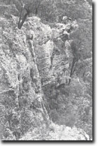 Cliffs of conglomerate (Strzelecki Group) above the Tyers River. |
© State of Victoria (Agriculture Victoria) 1996 - 2025.

This work, Victorian Resources Online, is licensed under a Creative Commons Attribution 4.0 licence. You are free to re-use the work under that licence, on the condition that you credit the State of Victoria (Agriculture Victoria) as author, indicate if changes were made and comply with the other licence terms.
The licence does not apply to ‘branding’ or some ‘images or photographs’ that may be owned by third parties. We ask you to seek prior approval to use images using the VRO feedback form. Access to higher quality images can also be provided on request.
This page was last updated on 25/01/2019.