
3. Erica - Walhalla Road Cuttings
This information has been developed from the publications:
|
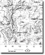
Location: | 483970 to 488984. Erica-Walhalla Road between the Thomson River Crossing and the hairpin bend on Coopers Creek. | |
Access: | Erica-Walhalla Road. | |
Ownership: | Crown Land (Road Reserve). | |
Geology/Geomorphology: | The type section for the boola Formation (Coopers Creek Formation) is exposed in road cuttings at this locality. The lower 25 metres of the formation consists of thin to massively bedded medium grained sandstones which are interbedded with quartz rich siltstone similar in appearance to the underlying Whitelaw Siltstone. The sandstone sequence is overlain by approximately 26 metres of well bedded siltstone, and then by approximately 140 metres of medium to thick bedded coarse grained clastics consisting of weathered greenstone and chert interbedded with siltstone. Several weathered greenstone and chert interbedded with siltstone. Several of the siltstones show slump folding features. The top of the sequence is marked by the rapid disappearance of the coarse grained sandstones and the appearance of siltstone and shale. The conformable contact with the underlying Whitelaw Siltstone is exposed at 484974 and is marked by a transition from dominantly siltstones to weathered fossiliferous sandstone beds. In addition, the contact of the Boola Formation with the Wilson Creek Shale is exposed at 488974 and is marked by a sharp transition from the siltstones of the Boola Formation to black paper shale characteristic of the Wilson Creek Shale. | |
Significance: | Regional. Type section of Boola Formation and also includes important contacts with Whitelaw Siltstone and the Wilson Creek Shale. | |
Management: | Maintenance of clear faces on the road cuttings would maintain the value of the site. | |
References: | VandenBerg , A.H.M. 1975. Definitions and descriptions of middle Ordovician to middle Devonian rock units of the Warburton district, East Central Victoria. Rep. geol. Surv., 1975/6. | |
© State of Victoria (Agriculture Victoria) 1996 - .

This work, Victorian Resources Online, is licensed under a Creative Commons Attribution 4.0 licence. You are free to re-use the work under that licence, on the condition that you credit the State of Victoria (Agriculture Victoria) as author, indicate if changes were made and comply with the other licence terms.
The licence does not apply to ‘branding’ or some ‘images or photographs’ that may be owned by third parties. We ask you to seek prior approval to use images using the VRO feedback form. Access to higher quality images can also be provided on request.
This page was last updated on .