
12. Mount Toorongo
This information has been developed from the publications:
|
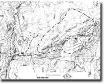
| Location: | 185108 to 230130. Mount Toorongo eleven kilometres north east of Noojee. | |
Access: | Mount McDonald Jeep Track. | |
Ownership: | Crown Land. | |
Geology/Geomorphology: | Mount Toorongo is the highest point of a ridge which has formed along the contact between the Toorongo Granodiorite and the metasediments of the associated aureole. The southern sides of the ridge are cliffed in parts exposing the metasediments which are evidently less resistant to erosion than the granodiorite. | |
Significance: | Regional. This is the best developed igneous contact ridge in the present study area. | |
Management: | Because of the area covered by the site, it is unlikely that limited land disturbance such as quarrying would detract from the significance of the site. | |
© State of Victoria (Agriculture Victoria) 1996 - .

This work, Victorian Resources Online, is licensed under a Creative Commons Attribution 4.0 licence. You are free to re-use the work under that licence, on the condition that you credit the State of Victoria (Agriculture Victoria) as author, indicate if changes were made and comply with the other licence terms.
The licence does not apply to ‘branding’ or some ‘images or photographs’ that may be owned by third parties. We ask you to seek prior approval to use images using the VRO feedback form. Access to higher quality images can also be provided on request.
This page was last updated on .