
10. Thomson Portal Road
This information has been developed from the publications:
|
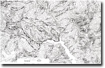
| Location: | 315277 to 363250. Road cuttings between Whitelaw Creek and the Thomson Portal. | |
Access: | Thomson Valley Road (Park Road). | |
Ownership: | Crown Land. | |
Geology/Geomorphology: | Road cuttings at this site display the bedding and lithologies characteristic of the Bullring Siltstone, Sinclair Valley Sandstone, and the Whitelaw Siltstone. The cuttings include the type sections of the Sinclair Valley Sandstone (330274) and the Bullring Siltstone (350266) and the poorly exposed contact between the Whitelaw Siltstone and the Sinclair Valley Sandstone at 323274. | |
Significance: | Regional. Site includes the type sections of the Sinclair Valley Sandstone, the Bullring Siltstone, and the contact with the overlying Whitelaw Siltstone. | |
Management: | Occasional grading of the road cuttings to maintain clear exposures would maintain the value of the site. | |
References: | VandenBerg , A.H.M. 1975. Definitions and descriptions of middle Ordovician to middle Devonian rock units of the Warburton district, East Central Victoria. Rep. geol. Surv.Vict., 1975/6 | |
© State of Victoria (Agriculture Victoria) 1996 - .

This work, Victorian Resources Online, is licensed under a Creative Commons Attribution 4.0 licence. You are free to re-use the work under that licence, on the condition that you credit the State of Victoria (Agriculture Victoria) as author, indicate if changes were made and comply with the other licence terms.
The licence does not apply to ‘branding’ or some ‘images or photographs’ that may be owned by third parties. We ask you to seek prior approval to use images using the VRO feedback form. Access to higher quality images can also be provided on request.
This page was last updated on .