
Land capability for residential development in the Erica-Rawson area
This report prepared in 1981 by L D Russell of the fromers Soil Conservation Authority, at the request of the town and Country Planning Board to aid the planning of use of land at Erica. Erica is a township on the Great Dividing Range, approximately 125 km due east of Melbourne (figure 1).
The Melbourne and Metropolitan Board of Works established the township of Rawson on freehold land just north of Erica to service the construction of the Thompson Dam.
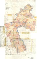
This report considered the capability of the land to sustain various types of residential use without detriment to the land and to water quality in the catchment to the Tyers River (a Proclaimed Water Supply Catchment), and to the Lower Thompson River.
Various types of land were identified, mapped and described and each is assessed for its capability to sustain –
(a) close urban development (subdivision to 0.1 hectare house-blocks, sewered and fully serviced)
(b) rural residential development (subdivision to 0.4 – 2 hectare house-blocks, sewered or unsewered and with limited servicing.
(c) hobby farm development (subdivision to 10 – 15 hectare lots, each with a house and on-site effluent disposal and access tracks, but without small dams).
Specific limitations to the forms of land use on each type of land were identified and, where practical, generalised management guidelines suggested.
To view the information PDF requires the use of a PDF reader. This can be installed for free from the Adobe website (external link).
 | (PDF 413KB) |
© State of Victoria (Agriculture Victoria) 1996 - 2025.

This work, Victorian Resources Online, is licensed under a Creative Commons Attribution 4.0 licence. You are free to re-use the work under that licence, on the condition that you credit the State of Victoria (Agriculture Victoria) as author, indicate if changes were made and comply with the other licence terms.
The licence does not apply to ‘branding’ or some ‘images or photographs’ that may be owned by third parties. We ask you to seek prior approval to use images using the VRO feedback form. Access to higher quality images can also be provided on request.
This page was last updated on 25/01/2019.