
6.2.2 Dissected plains (Heytesbury)
6. Western Plains (WP)
6.2 Sedimentary plains (Plains on unconsolidated (sedimentary) deposits
| In the Heytesbury region the drainage has been strongly influenced by the ridges and swales of strand lines left by the retreating late Tertiary (Neogene) sea, which has formed a rectilinear pattern of parallel arcuate tributaries running north-west to south-east, and so perpendicular to rivers draining south-west. The development of the drainage has been associated with the final Late Neogene uplift of the adjacent Otways Ranges, between 2 Ma and 1 Ma (Sandiford 2003). The deep dissection has exposed underlying Gellibrand marl, resulting in numerous landslides, many of which remain active. Associated soil types include acidic mottled texture contrast soils (Kurosols), acidic gradational soils (Dermosols), some sandy some with high organic matter content (Podosols). | 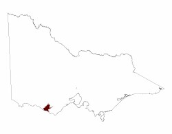 |
© State of Victoria (Agriculture Victoria) 1996 - .

This work, Victorian Resources Online, is licensed under a Creative Commons Attribution 4.0 licence. You are free to re-use the work under that licence, on the condition that you credit the State of Victoria (Agriculture Victoria) as author, indicate if changes were made and comply with the other licence terms.
The licence does not apply to ‘branding’ or some ‘images or photographs’ that may be owned by third parties. We ask you to seek prior approval to use images using the VRO feedback form. Access to higher quality images can also be provided on request.
This page was last updated on .