Soil Glossary D-G
A-C | D-G | H-R | S-Z | References | Soil Homepage
DERMOSOLIC: This is a term used as a Great Group distinction to describe Hydrosols in the Australian Soil Classification (Isbell, 2002) indicating that they have a structured B2 horizon. Apart from saturation of the greater part of the profile for prolonged periods (2-3 months) in most years, these soils would otherwise have been classified as Dermosols.
DERMOSOLS: Soil Order of the Australian Soil Classification (Isbell, 2002). Soils that have structured B2 Horizons more developed than weak throughout the major part of the horizon. They also lack strong texture contrast between the A and B horizons.
D HORIZON: Any soil material below the solum that is unlike the solum and C Horizon and is not a buried soil (McDonald et al, 1990).
DISPERSIBLE SOILS: Soils that are structurally unstable and disperse in water into basic particles i.e. sand, silt and clay. Dispersible soils tend to be highly erodible and present problems for successfully managing earth works (See Dispersion).
DISPERSION: Dispersion is an indicator of sodic soils as it occurs when excessive sodium is present. When water is added, the sodium attaches to the clay and forces the clay particles apart. This results in a cloud of clay forming around the aggregate. The fine clay particles that have dispersed, clog up the small pores in the soil and degrade soil structure as well as restricting root growth and water movement. Dispersive soils usually have a high Exchangeable Sodium Percentage (ESP). See Aggregate Slaking and Clay Dispersion and Dispersion in the Soil Health section of this website..
Gypsum (calcium sulphate) can be used as an ameliorant for dispersive soils. Gypsum initially provides an electrolyte effect to the soil, increasing its salt concentration. This prevents clay particles from swelling and therefore reduces dispersion. A longer term effect of gypsum is to replace exchangeable sodium attached to clay particles with exchangeable calcium which makes the soil less sodic and reduces dispersion.
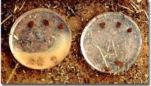 |
The petri dish on the left has three surface soil aggregates from the one soil at the top and three subsoil aggregates at the bottom. Note that no dispersion has occurred for the surface soil but that strong dispersion has occurred with the subsoil aggregates. The petri dish on the right has the same surface and subsoil aggregates placed in a gypsum solution. Note that no dispersion has taken place. This illustrates the immediate electrolyte effect of gypsum. |
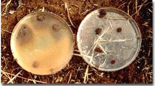 |
The same soil type (as above) has been wet up and remoulded (rolled into a ball) for the surface and subsoil and then placed into water (left petri dish). This simulates cultivating a soil while it is wet. Note that strong dispersion has occurred within the surface soil as well as the subsoil. Again, no dispersion has taken place in the gypsum solution (right petri dish), even after remoulding. |
Problems Caused by Dispersion
Dispersion in a soil has the following consequences:
- Dispersed clay particles block soil pores resulting in restricted water and air movement. If surface soil pores are blocked by dispersed clay, the soil becomes massive and when dry may form a surface crust or hardsetting layer. This will inhibit seedling emergence and water penetration. Increased surface cloudiness can also occur after cultivation.
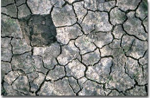
Surface crusting of a Sodosol. Crusting will result in reduced water infiltration as well as reduced plant emergence.
- Cultivation of soils that are wet may lead to smearing and compaction at cultivation depth. Formation of a resultant cultivation pan could further reduce air, water and root movement into the subsoil. Soil aggregates may not disperse immediately after wetting but may do so if cultivated or trampled by stock in a wet condition. The dispersion test on remoulded soil simulates this condition.
- Subsoil dispersion results in reduced water movement down the profile. Following heavy rainfall, waterlogging of the surface soil could also result. The consequent lack of oxygen in the root zone will deleteriously affect the crop (Daniels et al., 1994). During hot weather, there may also be excessive evaporation due to the restriction of drainage through the profile. On sloping land, lateral water movement may occur above the relatively impermeable subsoil horizon.
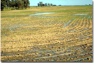
Waterlogging caused by built up water on an impermeable sodic subsoil.
- Subsoil dispersion also results in the structural breakdown of aggregates and increased soil density and hardness. Plant root movement will be restricted by the dense subsoil and much of the moisture and nutrients stored in the subsoil will not be used. Water and air movement will also be retarded.
- When wet dispersive soils have very little strength and are therefore more readily prone to gullying and tunnel erosion. Sodic clay subsoils are a major erosional problem if exposed or if the surface soil has been removed.
DURIPAN: Duripans are hard, subsurface horizons. They are cemented by silica or other materials such as iron oxides or calcium carbonate to the extent that fragments of the air-dry material will not slake after prolonged soaking in water or in Hydrochloric acid. They have a very firm or extremely firm consistence when moist and are always brittle, even after prolonged wetting (McDonald et al, 1990).
DYSTROPHIC: See base status.
EARTHS: A Great Soil Group (Stace et al., 1968) description defining a variable group of soils which are porous and sandy textured. They usually have an acidic trend (i.e. the pH decreases with depth), weak profile differentiation, diffuse horizon boundaries, an increase in clay content with depth and no A2 Horizon.
ELECTRICAL CONDUCTIVITY (EC): A measure of the conduction of electricity through water, or a soil water extract. The value can reflect the amount of soluble salts in a soil extract - therefore providing an indication of soil salinity. Saline soils are defined as those with an EC of greater than 1.5 dS/m for a 1:5 soil water extract and greater than 4 dS/m for a saturation extract. It can be interpreted in terms of the salinity tolerance of plants but soil texture needs to be considered in this interpretation.
ENDOACIDIC: Soils in which the major part of the profile deeper than 0.5 m is strongly acid. This term is used as a Subgroup distinction for Vertosols in the Australian Soil Classification (Isbell, 2002).
ENDOCALCAREOUS: A term used to describe a soil in which the major part of the profile deeper than 0.5 m is calcareous. This term is used as a Subgroup definition for the Vertosol Order in the Australian Soil Classification (Isbell, 2002).
ENDOHYPERSODIC: These soils deeper than a 0.5 m depth, have an ESP of 15 or more. This term is used as a Subgroup definition for Calcarosols and Vertosols in the Australian Soil Classification (Isbell, 2002).
EPIACIDIC: Soils in which the major part of the upper 0.5 m of the soil is strongly acid. This term is used as a Subgroup definition for Vertosols in the Australian Soil Classification (Isbell, 2002).
EPIBASIC: Epibasic is a term used in the Australian Soil Classification (Isbell, 2002) as a Subgroup descriptor for Calcarosols. It refers to Calcarosols that are not calcareous in the A1 or Ap horizon, or to a depth of 20 cm if the A1 horizon is only weakly developed.
EPICALCAREOUS: A soil in which the major part of the top 0.5 m of the profile is calcareous. It is used to describe Hydrosols and Vertosols in the Australian Soil Classification (Isbell, 2002).
EPIHYPERSODIC: Soils with at least one subhorizon within the top 0.5 m of the profile having an ESP greater than 15. Used as a Subgroup definition for Calcarosols and Vertosols in the Australian Soil Classification (Isbell, 2002).
EPIPEDAL: These soils have a pedal A Horizon, commonly blocky or polyhedral structure, with a moderate to strong grade and no surface crust. Used as a Great Group definition for Vertosols in the Australian Soil Classification (Isbell, 2002).
EPISODIC: These soils have an ESP of 6 or greater in the upper 0.1 m of the profile. This term is used as a Subgroup definition for Vertosols in the Australian Soil Classification (Isbell, 2002).
EXCHANGEABLE CALCIUM:MAGNESIUM RATIO (Exch. Ca:Mg): A ratio of exchangeable Calcium vs. exchangeable Magnesium in the soil. Soils with a low Ca:Mg ratio i.e. < 0.1 are considered to be Magnesic in the Australian Soil Classification (Isbell, 2002). A very low Ca:Mg ratio will in most cases indicate low exchangeable calcium levels (possible calcium deficiency for some plants).
EXCHANGEABLE SODIUM PERCENTAGE (ESP): Is calculated as the proportion of the cation exchange capacity occupied by the sodium ions and is expressed as a percentage. In Australia, sodic soils are categorised as soils with an ESP of 6-14% and strongly sodic soils have an ESP of 15% or greater.
EUTROPHIC: See base status.
FABRIC: Describes the appearance of the soil material (under a hand lens). Fabric differences are associated with the presence or absence of peds, the lustre of the ped surface and the presence, size and arrangement of pores in the soil mass (McDonald et al, 1990).
Fabric types include:
Earthy (or porous) (E): The soil material is coherent and characterised by the presence of pores with few if any peds. Soil particles are coated with oxides and/or clay particles are clumped around the pores.
Sandy (G): Soil material is coherent, with few if any peds. The soil mass appears as closely packed sand grains.
Rough-ped (R): Peds are evident and characteristically more than 50% of the peds are rough-faced, that is, they have relatively porous surfaces. They tend to have less clearly defined faces than smooth faced peds.
Smooth-ped (S): Peds are evident and more than 50% of them are dense and smooth faced, although the degree of lustre varies.
FACTUAL KEY: The Northcote Factual Key is a soil classification system that was developed by Keith Northcote in 1979. It is used to group Australian soils into recognisable Profile Forms. These are based on visible morphological properties (especially texture) and simple soil chemical properties and are labelled using an alphanumeric code (Northcote ,1979). |
 |
FERRIC HORIZON: A soil horizon containing more than 20% ferruginous nodules or concretions (also known as ironstone or buckshot) that are uncemented. The term is used as a definition for numerous Soil Orders in the Australian Soil Classification (Isbell, 2002). | 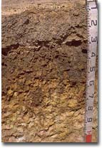 Ferric horizon (10-30 cm) within a Chromosol in the Corangamite region. |
FERROSOLS: Soil Order of the Australian Soil Classification (Isbell, 2002. These soils lack strong texture contrast between the A and B horizons. The B2 horizon has structure more developed than weak and a fine earth fraction which has a free iron oxide content greater than 5% (as opposed to a Dermosol). | 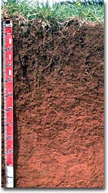 |
FIELD CAPACITY (FIELD MOISTURE CAPACITY): The percentage of moisture remaining in a soil horizon 2-3 days after being saturated (by rainfall or irrigation) and after free drainage has ceased.
FLUVIAL: A geomorphic process whereby sediments are transported and deposited by flowing river water.
FLUVIATILE: Relates to fluvial.
FRAGIPAN: Fragipans are earthy pans that are usually loamy. They seem to be cemented, with hard to very hard consistence when dry and moderate to weak brittleness when moist. However, a dry fragment slakes or fractures when placed in water (McDonald et al, 1990).
FRIABLE: The term friable refers to a soil property of consistence describing the resistance of a material to deformation or rupture. Consistence refers to the degree of cohesion or adhesion of the soil mass and is strongly affected by the moisture content of the soil. The terms friable and very friable refer to the weak force or very weak force between thumb and forefinger required to just break or deform a 20 mm piece of soil in a moist condition
GILGAI MICRORELIEF: Gilgai’s are common where they are Grey Vertosol soils. The land surface is irregular with alternating mounds (puffs) and depressions (hollows) and is commonly referred to as ‘crab hole’ country.
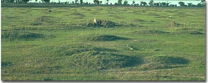
Gilgai microrelief in a paddock in the Horsham region. Note the well defined mounds.
Gilgai microrelief is formed due to clay horizons shrinking and swelling with alternate drying and wetting cycles (vertic properties). This forces ‘blocks’ of subsoil material gradually upwards to form mounds. The resultant soil on the mounds have properties which are more like Grey Vertosol subsoils (i.e lighter colour, more alkaline, presence of carbonate, higher salinity).
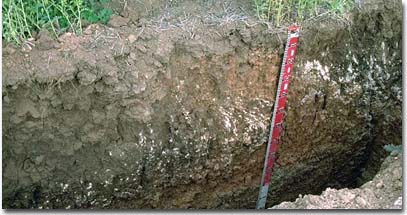
Variation in a soil profile across gilgai microrelief. Note the variation in calcium carbonate and subsoil colour across the profile.
Continuous cultivation of gilgai paddocks results in the smoothing out of these formations. However, the forces that created them are still operating, as is evident by the displacement of fence posts. If the land is left undisturbed for a number of wetting and drying seasons they will reform. In areas with gilgai microrelief crop and pasture growth is likely to be uneven across a paddock. This is due to soil variations and poor drainage conditions in the depressions.
GLEYING: Gleying is indicative of permanent or periodic intense reduction due to wetness and is characterised by greying, bluish or greenish color, generally of low chroma. Mottling may be prominent as well as rusty root channel mottling.
GRADATIONAL PROFILE FORM: A Primary Profile Form of the Factual Key (Northcote, 1979). It describes a soil with a gradual increase in texture (i.e. becomes more clayey) as the profile deepens. Gradational soils are given the notation "G". Boundaries are usually gradual or diffuse.
GRANULAR STRUCTURE: Rounded peds that are porous, stable and less than 12 mm in diameter. Granular structure usually occurs in the surface horizons (McDonald et al, 1990).
GREAT SOIL GROUPS: A soil classification system developed by Stace et al. (1968). It is based on the description of soil properties such as colour, texture, structure, drainage, lime, iron, organic matter and salt accumulation, as well as on theories of soil formation. The profile is assigned to a Great Soil Group classification based on its description. The system is limited in that central concepts are inadequately defined making confident identification of some described profiles difficult. This system is no longer in regular use in Australia but some of the terms are still used quite frequently (e.g. Krasnozems) to describe soils.
GREY, BROWN AND RED CALCAREOUS SOILS: A Great Soil Group classification,(Stace et al., 1968). These soils are shallow, soft, powdery or weakly structured loams to light clays containing finely divided carbonates throughout the profile and showing very little horizon development. They tend to develop from highly calcareous rocks which underlie them, at depths up to 50 cm from the surface. Fragments of limestone may also be found in the profile. The surface texture may be a loam or a clay loam, with a weak platey or a fine blocky structure. Below this, the structure is massive or more clayey with a medium blocky structure of rough faced peds. The clay content tends to increase about one texture class throughout the profile.
GREY, BROWN AND RED CLAYS: A Great Soil Group Classification, Stace et al., (1968). This is a broad group of soils which have a moderate to very deep profile. These soils crack deeply on drying and have a high clay content throughout. Subsoil clays range from grey to brown or red in colour gradually becoming paler with increasing depth. In Victoria, these soils are typically alkaline throughout most of the profile and carbonates may also be present.
GYPSIC: These soils contain more than 20% visible gypsum with a minimum thickness of 0.1 m that is of apparent pedogenic origin. If the upper boundary of the horizon occurs below the 1 m depth it is disregarded in the classification. It is used as a definition for a number of Orders in the Australian Soil Classification (Isbell, 2002).
GYPSUM: A naturally occurring soft crystalline material which is a hydrated form of calcium sulphate. Deposits occur naturally in inland Australia. Gypsum contains approximately 23% calcium and 18% sulphur. It is used to improve soil structure and reduce crusting in hard setting clayey soils.


