
Birch Creek Volcanic Complex and Berry Deep Lead
|
This information has been obtained from the report: Eruption Points of the Newer Volcanic Province of Victoria by Neville Rosengren. This report was published in 1994 and was prepared for the National Trust of Australia (Victoria) and the Geological Society of Australia (Victorian Division). The review of eruption points was based on an earlier unpublished manuscript Catalogue of the post-Miocene volcanoes of Victoria compiled by O P Singleton and E B Joyce (Geology Department, University of Melbourne 1970). |
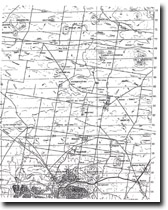
| 37 21 00S 143 55 00E; 7623-2-1 (Smeaton) 585624.9. 9 km N of Creswick. Lone Hand Road. | ||
Creswick. | ||
Almost all is private land apart from road reserves. Cleared, limited outcrop, mine dumps. | ||
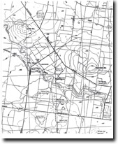
Type 6: | Scoria hills. | |
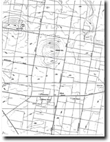
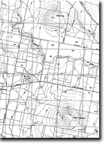
The area enclosed by this large site includes several large named scoria hills and cones, (Birch Hill, Mount Moorookyle, Powlett Hill, Stewart Hill & Kelly Hill, Clover Hill, Woodhouse Hill, Cattle Station Hill) and two unnamed volcanoes. It is selected as representative of the numerous smooth, steep, domal hills that are typical of the Central Hills and Plains lava fields between Creswick and Maryborough. The area lies adjacent to Mount Kooroocheang (formerly Smeaton Hill) which is treated as a separate site. This region has the highest concentration of scoria volcanoes in the Newer Volcanics Province and comprises a geological and geomorphological unit unique in Australia. The selected area lies over a deep lead system and there are strong visible reminders of nineteenth century mining endeavours in the form of shafts, mine head structures, pump houses and mine tailings (dumps). This type of mining activity was a direct consequence of the volcanism as the gold-bearing alluvial gravels had been buried by lava flows and volcanic ejecta. | ||
National: | It is not widely appreciated that the highest concentration of volcanic vents lies in the Creswick-Clunes area of the Central Highlands rather than the Western District Plains. This area is a clear illustration of the intensity of volcanic activity and in many ways is more obviously volcanic than much of the Western District Plains where eruption points are widely spaced or inconspicuous. In addition, the extensive remnants of mining activity are a clear indication of the role of volcanicity in burying a former landscape (here a river system) and the resources it contains (gold). | |
References: | King, R.L. 1985. Explanatory notes on the Ballarat 1:250 000 sheet. Geological Survey of Victoria Report 75. | |
 Birch Hill |
© State of Victoria (Agriculture Victoria) 1996 - 2025.

This work, Victorian Resources Online, is licensed under a Creative Commons Attribution 4.0 licence. You are free to re-use the work under that licence, on the condition that you credit the State of Victoria (Agriculture Victoria) as author, indicate if changes were made and comply with the other licence terms.
The licence does not apply to ‘branding’ or some ‘images or photographs’ that may be owned by third parties. We ask you to seek prior approval to use images using the VRO feedback form. Access to higher quality images can also be provided on request.
This page was last updated on 23/03/2020.