
GN15
| Group: Nagambie Landcare Group | |
| Australian Soil Classification: Bleached-Sodic (and Mottled), Eutrophic, Grey CHROMOSOL; loamy/clayey | |
| Northcote Factual Key: Dy 3.81 | Great Soil Group: no suitable group |
| General Landscape Description: The original vegetation included Yellow Box (Eucalyptus melliodora) and Grey Box (E. microcarpa). This site is adjacent to a prior stream channel which has been mined for sand. | |
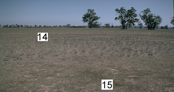 GN14 & 15 Landscape |
Soil Profile Morphology
Surface Soil
| A1 | 0-10 cm | Dark brown (10YR3/3); fine sandy loam; massive; firm consistence dry; pH 4.8; abrupt change to: | 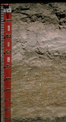 GN15 Profile |
| A2 | 10-30 cm | Light yellowish brown (10YR6/4) conspicuously bleached (5Y8/1d); fine sandy loam; massive (forms a hard capping from 27-30cm); contains very few (<2%) quartz fragments; firm consistence dry; pH 5.7; abrupt and wavy change to: | |
| Subsoil | |||
| B21 | 30-35 cm | Yellowish brown (10YR5/4) with yellowish brown (10YR5/8) mottles; medium clay; weakly structured; strong consistence dry; pH 5.6; clear change to: | |
| B22 | 35-50 cm | Greyish brown (10YR5/2) with bright yellowish brown (10YR5/8) mottles; light clay (sandy); with few (5-10%) quartz fragments; strong consistence dry; pH 5.9; gradual change to: | |
| B23 | 50-70 cm | Greyish brown (10YR5/2) with yellowish brown (10YR5/8) mottles; coarse sandy clay loam; indurated; strong consistence dry; with many (35%) quartz fragments (medium sized); gradual change to: | |
| 2A1 | 70-90 cm | Light grey (10YR7/2) with strong brown (7.5YR5/8) mottles; clayey sand (coarse); very firm consistence dry; abrupt change to: | |
| 2B2 | 90-105 cm | Light brownish grey (10YR6/2) with strong brown (7.5YR5/8) mottles; silty clay; strong medium polyhedral structure; contains very few (2%) quartz fragments; strong consistence dry; pH 6.7; abrupt change: | |
| 3A1 | 105+ cm | Pale brown (10YR6/3); coarse sandy clay loam. | |
Key Profile Features
- Hardsetting surface horizon.
- Strong texture contrast between surface (A) horizons and subsoil (B) horizons.
- Buried soil horizons occur.
Key Profile Characteristics
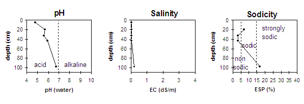
pH | Salinity Rating | |||
Surface (A1 horizon) | very strongly acid | very low | non-sodic | none |
Subsoil (B21 horizon) | moderately acid | very low | non sodic | none |
Deeper subsoil (at 1 m) | slightly acid | low | strongly sodic | strong |
 |
Management Considerations:
Profile
- Plant Available Water Capacity is low (estimated at 76mm) for this profile - based on the laboratory data available. PAWC is limited by the individual subsoil which also becomes sodic with depth.
Surface (A) Horizons
- The surface horizons have a very low overall nutrient status. However, total nitrogen and organic carbon levels appear satisfactory.
- The very strongly acid surface soil indicates that aluminium and manganese toxicity may occur. The exchangeable aluminium level measured in the laboratory is higher than for Site GN14 and may affect the growth of aluminium sensitive species such as barley, lucerne, medics, canola, phalaris and wheat. Raising the pH level of the surface soil will help reduce the toxicity. A lime test (sampled at the paddock level) may be appropriate to determine whether lime is needed to raise the pH. Deficiencies in molybdenum, calcium, magnesium and potassium may also restrict plant growth. These deficiencies may also be treated by adding lime.
- The conspicuously bleached A2 horizon suggests that periodic waterlogging occurs.
- The subsoil has a low wilting point (3.7%) which means that plants will be able to utilise light rains falling on relatively dry soil.
Subsoil (B) Horizons
- The deeper subsoil (from 90 cm) is strongly sodic and dispersive (with a low calcium:magnesium ratio of 0.15) This is likely to restrict water and root movement in the deeper subsoil.
- The subsoil horizons have a low overall nutrient status. The calcium:magnesium ratio is low for the entire subsoil which may cause calcium deficiency and lead to soil structural problems.
Comments from Landholder:
- Typical soil in area.
- Oats and phalaris cropped 20, but now used for pasture.
- Saline at depth.
- 12m to water table (some perched water tables in area).
- Low recharge area.

© The State of Victoria, 1996 - .
This page was last updated on .