
GBLRA023
Location: Benalla
Australian Soil Classification: Vertic (Sodic), Eutrophic, Grey CHROMOSOL
Northcote Factual Key: Dy2.22
General Landscape Description: Alluvial Plain.
Site Description: Flat plain.
Geology: Quaternary Alluvium.
Land Use: Pasture includes Phalaris sp.
Map Unit: Burns CFg
Native Vegetation: Red Gum (Eucalyptus camaldulensis).
Soil Profile Morphology:
Surface Soil
| A1 | 0-10 | Dark greyish brown (10YR4/2); loam (organic) coarse sandy; moderate very fine sub-angular blocky structure; rough ped fabric; firm consistence dry; pH 5.3; clear change to: |
| A2 | 10-20 | Light olive brown (2.5Y5/3), (2.5Y6/3 dry); light clay, fine sandy; massive to weakly structured; rough ped fabric; firm consistence dry; organic staining present; pH 5.6; gradual change to: |
Subsoil | ||
| B21 | 20-40 | Dark greyish brown (10YR4/2); medium heavy clay; possible lenticular structure breaking to strong fine sub-angular blocky and lenticular structure; smooth ped fabric; very firm consistence moderately moist; pH 6.2; gradual change to: |
| B22 | 40-70 | Dark greyish brown (10YR4/2); heavy clay; possible lenticular structure breaking to strong fine sub-angular blocky and lenticular structure; smooth ped fabric; very firm consistence moderately moist; pH 7.1. |
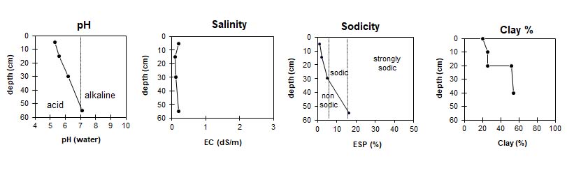
Soil Profile Characteristics:
pH | Salinity Rating | |||
Surface (A1 horizon) | Strongly Acid | Medium | Non-Sodic | None |
Subsoil (B21 horizon) | Slightly Acid | Low | Non-Sodic | None1 |
Deeper Subsoil (at 40-70 cm) | Slightly Alkaline | Low | Strongly Sodic | Strong2 |
|
|
|
|
Chemical and Physical Analysis:
Horizon | Horizon Depth (cm) | pH (field) | pH (water) | pH (CaCl2) | EC ds/m | Organic Carbon g/100g | Total Nitrogen % | Exchangeable Cations | Exchangeable Acidity meq/100g | Coarse Sand (0.2-2.0mm) | Fine Sand (0.02-0.2mm) | Silt (0.002-0.02mm) | Clay (<0.002mm) | |||
Ca | Mg | K | Na | |||||||||||||
meq/100g | ||||||||||||||||
A11 | 0-10 | 6.0 | 5.3 | 4.6 | 0.19 | 3.2 | 0.27 | 3.4 | 1.9 | 0.5 | 0.3 | 15 | 8 | 34 | 26 | 21 |
A12 | 10-20 | 6.5 | 5.6 | 4.5 | 0.1 | 2.3 | 2.1 | 0.4 | 0.3 | 8 | 7 | 36 | 26 | 26 | ||
B21 | 20-40 | 7.0 | 6.2 | 4.9 | 0.12 | 3.3 | 6.5 | 0.5 | 1.1 | 9.6 | 4 | 21 | 16 | 52 | ||
B22 | 40-70 | 8.0 | 7.1 | 6.0 | 0.19 | 4.6 | 9.1 | 0.4 | 2.8 | 4 | 22 | 15 | 54 | |||
Profile Described By: Nathalie Baxter and Mark Hocking (1998).

© The State of Victoria, 1996 - .
This page was last updated on .