
GN22
| Location: East Shepparton Landcare Group. | Australian Soil Classification: Vertic (and Calcic), Mottled-Mesonatric, Red SODOSOL. |
| Northcote Factual Key: Dy 3.33 | Great Soil Group: red-brown earth |
| General Landscape Description: Level plain. This site has been mapped as Orrvale Sandy Loam by Skene and Freedman (1944). | |
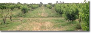 Site GN22 Landscape |
Soil Profile Morphology:
Surface Soil
| A1 | 0-40cm | Brown (7.5YR44); fine sandy loam; hardsetting surface condition; weakly structured; weak consistence dry; contains very few (2%) quartz gravels (2-5 mm size); pH 6.3; sharp change to: | 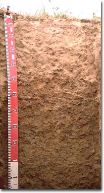 Site GN22 Profile |
| A2 | 40-45cm | Reddish yellow (7.5YR6/6), sporadically bleached; fine sandy loam; massive; firm consistence dry; contains very few (2%) quartz gravels (2-5 mm size); pH 6.6; sharp and discontinuous change to: | |
| Subsoil | |||
| B21 | 45-70cm | Yellowish red (5YR5/6) with yellowish brown (10YR5/4) mottles; medium clay; strong coarse blocky structure; firm consistence moist; contains few (5%) manganese stains and very few (2 %) quartz gravels; pH 6.6; clear change to: | |
| B31 | 70-90cm | Pale brown (10YR6/3) with brownish yellow (10YR6/6) mottles; medium heavy clay; strong coarse blocky structure; some slickensides present; firm consistence moist; contains few (2-5%) soft and hard carbonate and a few (5%) manganese flecks; pH 8; gradual change to: | |
| B32 | 90-120cm | Light olive brown (2.5Y5/4) with reddish brown (5YR5/4), yellowish red (5YR5/6)and brown (10YR5/3) mottles; medium heavy clay; strong medium polyhedral structure; firm consistence moist; contains very few (1%) carbonate nodules and a few (2-5%) manganese flecks; pH 8.2; gradual change to: | |
| B33 | 120-150cm | Pale brown (10YR6/3) with brownish yellow (10YR6/6) mottles; light medium clay; strong fine polyhedral structure; firm consistence moist; contains pockets of fine sand; pH 8.4; gradual change to: | |
| B34 | 150-200cm | Light reddish brown (5YR6/3) with yellowish brown (10YR5/6) and light brownish grey (10YR6/2) mottles; light medium clay; weak consistence moist; micaceous; contains a few (5-10%) manganese nodules and stains; pH 8.3. | |
Key Profile Features:
- Strong texture contrast between surface (A) horizons (11 % clay) and subsoil (B21) horizon (47% clay).
pH | Salinity Rating | |||
Surface (A1 horizon) | slightly acid | medium-high | sodic | none1 |
Upper subsoil (45 - 70 cm) | slightly acid | low-medium | strongly sodic | moderate |
Deeper subsoil (90 - 120 cm) | moderately alkaline | high-very high | strongly sodic | - |
Deep subsoil (150-200 cm) | moderately alkaline | low-medium | - | - |
Management Considerations:
Whole Profile
- Plant available water capacity (PAWC) is considered to be low-medium (estimated at 100 mm). This is based on available laboratory data and assumes an effective rooting depth of about 70cm. Effective rooting depth will be restricted by the high level of soluble salts in the 70-120 cm zone.
Surface (A) Horizons
- The surface soil has a high combined fine sand and silt content (i.e. 74%) and will tend to become hardsetting when dry. Organic matter is important for maintaining aggregation on such soils and preventing slaking. Organic matter levels can be improved by minimising or avoiding cultivation, incorporating organic materials and mulching.
- The level of organic carbon and nitrogen measured at the soil pit site is relatively low. This may not, however, be representative of the larger area around this site. Increasing organic matter levels will assist in improving soil fertility as well as water holding capacity.
Subsoil (B) Horizons
- The level of soluble salts becomes high in the subsoil from 70 cm depth. This is likely to result in restricted growth of salt sensitive species.
- The coarsely structured upper subsoil is strongly sodic and disperses moderately. Also, the calcium:magnesium ratio becomes less than one. This is likely to cause conditions which result in restricted root and water movement through the subsoil. Water may build up on top of the subsoil after heavy rains. This is likely to result in the lower surface soil becoming "spewy" as a result. The sporadically bleached subsurface horizon indicates that periodic waterlogging probably occurs.
Comments from Landholder:
- Over the last 3 years peach and apricot trees have been dying.
Profile Described By: Mark Imhof, Paul Rampant, Sonia Thompson (1996).

© The State of Victoria, 1996 - 2025.
This page was last updated on 23/03/2020.