
GN21
| Location: East Shepparton Landcare Group. | Australian Soil Classification: Sodic, Calcic, Brown CHROMOSOL |
| Northcote Factual Key: Dy 2.33 | Great Soil Group: red-brown earth |
| General Landscape Description: Lower lying position on a level plain. This soil has been mapped as Congupna Clay Loam by Skene and Freedman (1944). | |
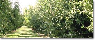 Site GN21 Landscape | |
Soil Profile Morphology:
Surface Soil
| A1 | 0-15cm | Brown (7.5YR4/2); fine sandy clay loam, hardsetting surface condition; weakly structured; very strong consistence dry; rusty root channel mottling present; pH 6.4; sharp change to: | 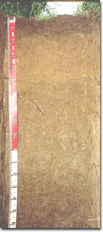 Site GN21 Profile |
| Subsoil | |||
| B21 | 15-30cm | Strong brown (7.5YR5/6) with pale brown (10YR6/3) mottles; medium heavy clay; moderate coarse blocky structure; strong consistence moist; pH 6.1; gradual change to: | |
| B22 | 30-50cm | Brownish yellow (10YR6/6); medium heavy clay; moderate coarse blocky structure; very strong consistence moist; pH 5.4; clear change to: | |
| B23 | 50-80cm | Yellowish brown (10YR5/6); medium heavy clay; moderate coarse blocky structure; very firm consistence moist; contains a few (5-10%) dark manganese flecks; pH 6.8; clear change to: | |
| B24 | 80-95cm | Similar to above, but structure becomes moderate medium polyhedral; contains very few (2%) soft carbonates; pH 7.8: | |
| B31 | 95-120cm | Pale brown (10YR6/3) with brownish yellow (10YR6/6) and strong brown (7.5YR5/6) mottles; light medium clay; moderate medium polyhedral structure; firm consistence moist; contains very few (1%) soft carbonates and some dark manganese stains; pH 7.8; gradual change to: | |
| B32 | 120-160cm | Light brownish grey (10YR6/2) with brownish yellow (10YR6/6) mottles; clay loam (fine sandy); moderate medium polyhedral structure; firm consistence moist; contains patches of sand; pH 8.2: | |
| B33 | 160cm+ | Light medium clay; pH 8.2. | |
Key Profile Features:
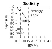
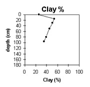
- Strong texture contrast between surface (A1) horizon (26% clay) and subsoil (B21) horizon (54% clay).
Soil Profile Characteristics:
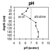
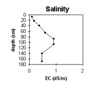
pH | Salinity Rating | |||
Surface (A1 horizon) | slightly acid | very low | non-sodic | none |
Upper subsoil (15 - 30 cm) | slightly acid | very low | non-sodic | none |
Deeper subsoil (95 - 120 cm) | slightly alkaline | high | strongly sodic | - |
Deep subsoil 160 cm + | moderately alkaline | low-medium | - | - |
 |  |  |
 |  |
Management Considerations:
Whole Profile
- Plant available water capacity (PAWC) is considered to be medium (estimated at 135 mm) for the top metre of this profile. This is based on available laboratory data and should be considered as a potential capacity since root movement will be restricted by the coarsely structured subsoil. Also, the level of soluble salts becomes high between 80 -120 cm in the profile.
Surface (A) Horizon
- The surface soil has a high combined fine sand and silt content (i.e. 65%) and sets hard when dry. Organic matter is important for soils such as these in order to maintain soil aggregate stability.
Subsoil (B) Horizons
- The coarsely structured upper subsoil is non-sodic but disperses moderately in water. This will result in some restriction to root and water movement through the subsoil. The presence of rusty root channel mottling in the surface horizon indicates that some waterlogging occurs above the relatively slowly permeable subsoil.
- The deeper subsoil becomes sodic and the calcium:magnesium ratio is low (<1), suggesting that root and water movement will be more restricted at depth.
- The level of soluble salts becomes high in the 80-125 mm zone. This is likely to restrict the growth of deeper-rooted salt sensitive species.
Comments from Landholder:
- This is the lowest part of the property.
- Managed similarly to site GN20.
- Pears have been grown here for 60 years.
Profile Described By: Mark Imhof, Paul Rampant, Sonia Thompson (1996).

© The State of Victoria, 1996 - 2025.
This page was last updated on 23/03/2020.