
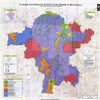
A Land Capability Study in the Shire of Mitchell
This study describes in detail the land present in the Shire of Mitchell and provides information relevant to land use planning and assessment. It was prepared in 1996 by Evan Jones et al of the former Department of Natural Resources and Environment.
The Shire of Mitchell is an amalgamation of part or all of the former Shires of Kilmore, Wallan, Broadford, Pyalong, McIvor and Seymour. The Shire is 2870 km2 in area and is located on the fringe of the northern growth corridor of Melbourne. Population growth within the Shire increased considerably in the 1990s, and the trend was expected to continue. The use of Land Capability information is expected to assist the Shire of Mitchell in identifying land with major physical limitations for urban and rural development, aid decision making where competing land uses occur, and be invaluable in the preparation or revision of planning strategies for future development.
 | A Land Capability Study in the Shire of Mitchell (PDF - 2757 KB) A Land Capability Study in the Shire of Mitchell (5321 KB) To view the information PDF requires the use of a PDF reader. This can be installed for free from the Adobe website (external link). |
 Land Capability Study of the Shire of Mitchell
Related Links on VRO

© The State of Victoria, 1996 - .
This page was last updated on .