Your gateway to a wide range of natural resources information and associated maps

Victorian Resources Online

GL9 (8422) Maringa Creek

This information has been developed from the publications:

    • Sites of Geological and Geomorphological Significance in Central Gippsland (1981) by Neville Rosengren, M.S McRae-Williams and S.M Kraemers.
    • Sites of Geological and Geomorphological Significance in the Gippsland Lakes Catchment (1984) by Neville Rosengren.
    • Sites of Geological and Geomorphological Significance in East Gippsland, Victoria (1981) by Neville Rosengren, M.S McRae-Williams
Geological heritage sites, including sites of geomorphological interest and volcanic heritage sites, are under regular revision by the Geological Society of Australia, especially in the assessment of significance and values. Reference should be made to the most recent reports. See the Earth Science Heritage section of the Geological Society of Australia website for details of geological heritage reports, and a bibliography.


Location:824076. Two kilometres west of Kalima.
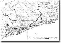
Image:  East Gippsland Sites of Significance
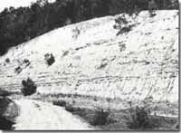
Road cutting exposing Jemmys Point Formation - Maringa Creek

Abstract:

Exposure of Jemmys Point Formation.

Access:

Kalima - Nungurner Road.

Ownership:

Private land.

Geology:

A road cutting along Maringa Creek exposes five to eight metres of cross-bedded sands and sandy clays included coloured horizons and beds with well-preserved molluscan fauna of the Jemmys Point Formation.

Geomorphology:

The mouth of Maringa Creek is constricted by a sand pit, behind which a broad salt marsh has developed.

Significance:

Local. The site currently provides a relatively clear exposure of Jemmys Point Formation.

Management:

Road cuttings in the Tertiary sediments deteriorate rapidly due to slope wash and gullying, and this site would be enhanced by occasional grading.


GL 1 to 9
Sites GL 1-9

Page top