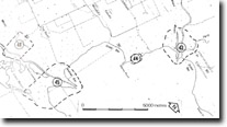
GL43 (8321) Avon - Perry Delta
|
This information has been developed from the publications:
|
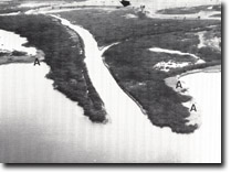
| Location: | 234887 (8321). 1.5 kilometres south-east of Strathfieldsaye. |  Reed-fringed prograding delta of Avon-Perry deltas. Phragmites (A) Marginal Bluff (arrowed) |
Abstract: | Cuspate delta. | |
Access: | Boat in Lake Wellington. | |
Ownership: | Mainly Crown land. | |
Geomorphology: | The Avon River has a reed-fringed delta extending 600 metres into Lake Wellington. As with other deltas in the lakes, sedimentation has first filled an embayment formed by the drowning of the Avon - Perry Valleys, and with the protection afforded by a vigorous growth of reed swamp, a small cuspate delta has grown south-east into Lake Wellington. There is still a broad zone of Phragmites growing on the lake shore of the eastern arm of the delta and a narrower reed swamp zone of Phragmites and Cladium fringes the banks of the Avon and Perry rivers for some distance upstream from the delta mouth. Phragmites has largely disappeared from the western arm of the delta, and the lake shoreline of this arm is eroding. | |
Clydebank Moss is an extensive back swamp that occupied the infilled western side of the Avon valley downstream from the Clydebank Bridge. There has been a marked change in the sediment load of the Avon River in recent years, evidenced by the extensive shallowing of the river channel downstream from Stratford and the development of extensive gravel and sand shoals in the river. During floods, much of this sand is moved downstream to the delta and into Lake Wellington. Deposition of this material may offset in part the erosion of the silts and muds of the delta, exposed as a result of reed swamp die-back, but it probably is of insufficient amount to contribute to extended delta growth. | ||
Significance: | Regional. The delta illustrates the conditions that must have existed on the Tambo River before the disappearance of reed swamp there, and the onset of erosion. | |
Management: | To maintain the delta, it is necessary to minimize the physical disturbance to the reed swamp and Melaleuca swamp. Grazing and clearing of the site should be prohibited. As with the LaTrobe delta, the maintenance of the feature is dependent upon continued undiminished river flow. Thus, any water diversion upstream must be evaluated in the light of the potential impact of such work on physiographic and ecological changes on the delta and shore of Lake Wellington. | |
References: | Jenkin, J.J. (1968). "The geomorphology and Upper Cainozoic geology of Southeast Gippsland, Victoria." Geol. Surv. Vict. Memoir 27. Bird, E.C. F. (1978). The Geomorphology of the Gippsland Lakes Region. Publication No. 186, Environmental Studies Series, Ministry for Conservation, Victoria. | |

Sites GL43-46


