GL17 (8422) Salt Lake (Taylors Swamp)
|
This information has been developed from the publications:
|
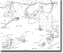
| Location: | 745035 (8422). Boole Poole Peninsula 1.5 kilometres south-west of Metung. | |
Abstract: | Salt pan and salt swamp. | |
Access: | Boat to northern shore of Boole Poole Peninsula. | |
Ownership: | Predominantly Crown land (Gippsland Lakes Coastal Park). | |
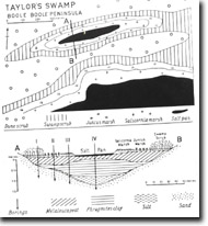
Geomorphology: | The northern margin of Boole Poole Peninsula contains extensive swamp land developed in depressions between dune ridge crests and other low lying sites. Originally these wetlands consisted of Phragmites and Melaleuca swamp, but much of this has been replaced by more salt tolerant marsh plant such as Juncua maritimus and Salicornia australis as a result of increasing salinity of lake waters and swampland soils. | |
Significance: | Salt Lake is an enclave of salt marsh which encloses an unvegetated salty lagoon or salt pan with soil salinity values in excess of 100%. Borings into the pan and marsh deposits indicate the swamp was initially a freshwater lagoon that was invaded by Phragmites australis then by swamp scrub. Inundation by the brackish waters of Lake King caused a build-up of salinity values in the swamp to the levels which Melaleuca cannot tolerate and caused die-back and replacement of these with salt tolerant species. | |
Management: | Regional. This site is a clear example of the process which has changed the floral composition of extensive swamplands bordering Lake King and Victoria. | |
The area is sensitive to changes in soil moisture and salinity levels and land use which may alter these would need to be evaluated in terms of its specific impact. | ||


