8822-8 Tidal Delta - Mallacoota Inlet
Sites 8822 1 to 10 - Mallacoota to Cape Howe
This information has been developed from the publications:
|
Location: | 445400. A group of islands and shoals in the Lower Lake of Mallacoota Inlet. |  Sites 8822-1 to 10 |
Abstract: | Low salt marsh islands separated by intertidal sand flats and tidal channels | |
Access: | Boat from Mallacoota Inlet Jetty. | |
Ownership: | Crown Land (Croajingolong National Park). | |
Geology: | The tidal delta consists of a basement of marine sand overlain by an alternating sequence of sands, sandy silt and silty clays. The sand is similar tot hat of the ocean beach consisting mainly of iron stained quartz with small amounts of feldspars and carbonates. The sand is of marine origin an has been carried into the Inlet at flood tide and deposited as the tidal current slackens and spreads into the Lower Lake. The alternation of finer sediments with the sand indicates periods when the entrance has been closed and ocean waves and tidal flow excluded from the Inlet allowing deposition of silts and clays. The orientation of bedforms on the intertidal sand of the delta (mega-ripples and sand waves) indicates a net movement of sediment into Mallacoota Inlet resulting in an extension of the sandflat area. | |
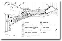
Geomorphology: | The delta consists of sand and saltmarsh flats dissected by tidal channels. Low scrub covered sand ridges occur on the larger islands. The delta is largely submerged at high tide but at low tide extensive sand flats are exposed traversed by a single main channel up to three metres deep. This channel on the west of the delta accounts for most of the tidal ventilation. Most of the islands are now bounded by low cliffs cut in the salt-marsh peats and soils indicating erosion of these formerly more extensive deposits. | |
Significance: | State. This is the largest estuarine tidal delta on the Victorian coast. The stratigraphy contrasts with the sandy thresholds described from New South Wales which consist entirely of sand. | |
Management: | Building construction and dumping of dredge spoil on the islands should be prohibited. Stricter control on boat speed in adjacent channels is necessary to reduce shoreline erosion. | |
References: | Bird, E.C.F. 1967. 'Depositional features in estuaries and lagoons on the south coast of New South Wales' Aust. Geogr. Studies. 5. Reinson, G.E. 1973. Aspects of Weathering and Sedimentation in the Genoa River Basin and Estuary, New South Wales-Victoria. Ph. D. Thesis (unpub) A.N.U. Wiliams, M.S. 1981. Mallacoota Inlet - A Geomorphological Assessment. Occasional Paper, Volume I, Number 4, Melbourne State College. | |

Tidal delta morphology - Mallacoota Inlet (from Williams, 1981)


