
8822-6 Howe Flat - Lake Barracoota
This information has been developed from the publications:
|
Location: | 454405 to 545425. This area extends east from Mallacoota Inlet for approximately 10 km to the southern spur of the Howe Range. | 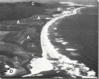 Howe Flat (A), Lake Barracoota (B), Howe Range (C), Tidal delta of Mallacoota Inlet. |
Abstract: | Low sand ridges, coastal wetland and freshwater lake – former estuarine arm of Mallacoota Inlet. | |
Access: | Boat landing may be made from Mallacoota Inlet. A 4-wheel drive track leads to the lake and Howe Flat from Bucklands farm on North-East Arm. | |
Ownership: | Crown Land (Croajingolong National Park). | |
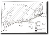
Geology: | Tertiary non-marine sediments underly the area. Superficial geology consists of Pleistocene and Holocene beach and dune sands, muds and organic material. | |
Geomorphology: | Howe Flat and Lake Barracoota occupy a former extension of Mallacoota Inlet now largely filled by sedimentation and swamp encroachment. Howe Flat is a complex wetland that includes low sand ridges, salt marsh, brackish and freshwater swamp and small shallow lagoons and pan fringed on the seaward margin by a dune-capped sand barrier. The barrier and its dune capping are only a single narrow ridge near Mallacoota Inlet but this broadens in the lee of Tullaberga Island into a labate foreland and from this blowouts and low transverse ridges are extending onto the lowlands of Howe Flat. There is lomnological and geomorphological evidence that an estuarine environment existed in the Howe Flat/Lake Barracoota are during the mid-Holocene and that this estuary has been largely filled by the growth of sand bars, spits and beach and dune ridges. Stages in the infilling of this former estuary may be deduced from studies of the morphology, sedimentology and palaeontology of the deposits of Howe Flat. The westernmost part of Howe Flat consists of closely spaced, low parallel and curving sand ridges similar in dimension to active spits in Howe Bight and indicates the importance of wave refraction in Mallacoota Inlet in shaping shoreline topography. There is some evidence from the Howe Flat terrain that water levels inside Mallacoota were higher during mid-Holocene times than they are now, suggesting either a higher sea level at the time or subsequent tectonic activity to raise the coastal lowland. The northern margin of Howe Flat is a low buff of Tertiary sediments in part mantled by sands of a Pleistocene barrier and dune formation. The sands of this older inner barrier are deeply leached with dark iron stained lower soil horizons. Eroded remnants of this barrier occur as part of the Goodwin Sands in Mallacoota Inlet. Lake Barracoota is a permanent freshwater lake at the eastern part of Howe Flat. The eastern shoreline lies against a granite spur of the Howe Range but all other shorelines are backed by dune sand or swamp deposits. Beaches at the eastern and western shores and spits along the southern shore are formed from sand blown into the lake from coastal dunes and which is being moved by wave and wave currents. Sand is spilling into the lake from active parabolic dunes at two points along the southern shore. Other lake shorelines are fringed by Baumea rubiginosa, Eleocharis sphacelata and Trigloching procera, with Phragmites australis at points of fresh water inflow. Behind the reeds and sedges are extensive thickets. | |
Significance: | State. This is the largest continuous coastal wetland in Croajingolong National Park and it has a complex geomorphological history. Stages in the reclamation of the former inlet are preserved in the surface features of the marsh and these may be compared with the active sedimentation that is occurring in Mallacoota Inlet. Radiocarbon dates of marine shells recovered from beneath Howe Flat have been quotes as evidence of a Holocene higher sea level and there is some geomorphological evidence to support this. The question of Holocene sea levels is one of continuing interest to coastal geomorphologists and other and the Howe Flat sites warrant more detailed investigation. | |
Management: | Drainage and land reclamation cause compaction and subsidence of the sediments and diminish the value of the site for Quaternary studies. The catchment of Lake Barracoota should be protected to prevent deterioration of the water quality of the lake. | |
References: | Gill, E.C. and Hopeley, D. 1972. 'Holocene sea levels in eastern Australia : a discussion', Marine Geology, 12 :223-233. Timms, B.V. 1973. ' A limnological survey of the Freshwater Coastal lakes of East Gippsland, Victoria', aust. J. Mar. freshw. Res., 24 :1-20. Williams, M.S. 1981. Mallacoota Inlet - A Geomorphological Assessment. Occassional Paper, Volume I, Number 4, Melbourne State College. | |
 Sites 8822-1 to 10 |
© State of Victoria (Agriculture Victoria) 1996 - 2025.

This work, Victorian Resources Online, is licensed under a Creative Commons Attribution 4.0 licence. You are free to re-use the work under that licence, on the condition that you credit the State of Victoria (Agriculture Victoria) as author, indicate if changes were made and comply with the other licence terms.
The licence does not apply to ‘branding’ or some ‘images or photographs’ that may be owned by third parties. We ask you to seek prior approval to use images using the VRO feedback form. Access to higher quality images can also be provided on request.
This page was last updated on 23/03/2020.