8723-6 Mount Kaye Range
|
This information has been developed from the publications:
|
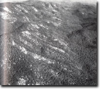
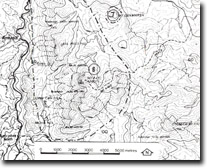
Location: | 986587. Six kilometres north-east of Noorinbee North |  Granite slopes and tor fields - Mount Kaye Range. |
Abstract: | Exposure of Noorinbee Granodiorite. | |
Access: | Mount Kaye Track. | |
Ownership: | Crown Land. | |
Geology/Geomorphology: | An extensive outcrop of Noorinbee Granodiorite has been faulted along north-south trend, and the fault zone incised by the Cann River. On the eastern side of the valley, the Mount Kaye Range rises to over 1000 metres, and display bare, planner and convex slopes with minor peak-top tors. The rock is a medium-grained black and white granodiorite. Minor streams draining the range have steep gradients, dropping more than 300 metres over low falls and cascades to the local base level created by the downcutting of the Cann River. | |
Significance: | Local. Abundant outcrop of Noorinbee Granodiorite with tor fields and vegetation-free slopes. | |
Management: | The large scale nature of the geological and geomorphological features of the site and the inaccessible nature of the area limit the potential impact of future land use on site significance. | |
 Sites 8723-6 7 |


