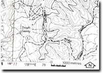
8723-5 Tonghi Swamp
|
This information has been developed from the publications:
|
Location: | 781500. 10 kilometres south of Combienbar | |
Abstract: | Possible structural control of alluvial deposition. | |
Access: | Parsons Road. | |
Ownership: | Crown Land. | |
Geology: | An alluvial deposit occurs on granite in the tributaries of Tonghi Swamp Creek. | |
Geomorphology: | The Tonghi Swamp occupies an alluvial basin at the head of Tonghi Swamp Creek. The origins of this features suggest some form of structural control (e.g. recent back tilting along the fault to the north and subsequent stream capture of the headwaters of Sixteen Mile Creek by Tonghi Swamp Creek). | |
Significance: | Unknown. Clarification of the origin of this feature requires more detailed investigation. | |
Management: | Land use which would result in the alteration of the catchment characteristics of the Tonghi Swamp should be restricted until investigation has indicated the significance of the site. | |


