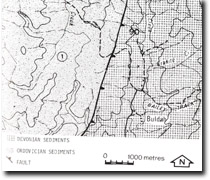
8723-1 Buldah Gap
|
This information has been developed from the publications:
|
Location: | 880730. Between Buldah and Granite Mountain. | |
Abstract: | Exposures of Ordovician and Devonian sediments and their faulted contact. Rectangular drainage pattern in Tennyson Creek. | |
Access: | Walk along Cann River and Tennyson Creek from Buldah Road. | |
Ownership: | Predominantly Crown Land with a small area of private property at Buldah. | |
Geology: | Devonian yellow and grey quartzose sandstones and conglomerates outcrop in the Cann River downstream from its junction with Tennyson Creek. These sediments are faulted against Ordovician sandstones and Shales. The faulting has produced drag effects in the Devonian sediments and dips increase from approximately 6º near Buldah to great than 30º near the fault contact. The Ordovician sediments are tightly folded and show strong cleavage and jointing. The drainage pattern developed by Tennyson Creek on these sediments is basically rectangular in form. The occurrence of this pattern on Ordovician sediments is unusual and suggests some form of unmapped structural control if the drainage system. | |
Significance: | Regional. The steepening dips in Devonian sediments associated with faulting are well exposed in the Cann River. | |
Management: | The large scale nature of the features of geological and geomorphological significance at this site are insensitive to land use change, and the flooding of Tennyson Creek and the upper west branch of the Cann River through reservoir construction would obscure the value of this site. | |


