8722-9 Mount Drummer
|
This information has been developed from the publications:
|
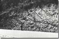
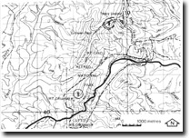
Location: | 070406 to 095429. 18 kilometres east of Cann River |  Fault (dotted)in Ordovician sediments - Princess Highway near Mt Drummer. |
Abstract: | Exposures of Drummer Granodiorite, faulting in Ordovician sediments and bismuth mineralisation. | |
Access: | Princess Highway and Bismuth Mine Track. | |
Ownership: | Crown Land, (predominantly Alfred National Park) | |
Geology: | The drummer Granodiorite is one of the best known units of the Bega Batholith, an extensive exposures of unweathered rock occur in road cuttings on the Princess Highway. The rock is a medium grained biotite-hornblende granodiorite. The granodiorite is faulted against Ordovician sediments to the east of Mount Drummer, and a clear exposure of the fault zone is seen in a new roadcutting on the Princess Highway. Th fault zone occurs entirely in Ordovician sediments. In the west of the section the dips in the near horizontally bedded Ordovician sandstones and shales are markedly increased as the fault zone is approached, The fault zone extends for approximately 100 metres and is characterised by brecciated sediments and minor folds. To the north of Mount Drummer, in the contact zone between the granodiorite and Ordovician sediments, and close to the Drummer Fault zone, bismuth mineralisation associated with quartz veins occurs. The site is marked by an open shaft and mineral specimens are easily obtained from the small amount of ore occurring around the shaft. | |
Significance: | Regional. Faulted exposures of the quality of that displayed at Mount Drummer are rare in the region. Sections which display the characteristics of the granitic rocks and provide access to fresh rock samples are uncommon. Bismuth mineralisation occurs at several localities in the eastern part of the study area, although none of these are as accessible as the Mount Drummer deposit. | |
Management: | Maintenance of clear faces on the road cuttings, particularly in the area of the fault is important if the quality of the sits is to be maintained. The Bismith mine shaft is approximately eight metres in depth, an is located on the margin of the Bismuth mine Track, and may represent a danger to the unsuspecting or careless observer. | |


