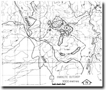
8722-8 Mount Everard
|
This information has been developed from the publications:
|
Location: | 015230. Three kilometres north-east of Thurra River bridge on Point Hicks Road. | |
Abstract: | Granite peak. | |
Access: | Four-wheel drive track from Cicada Trail near Mueller River crossing. | |
Ownership: | Crown Land (Croajingolong National Park) | |
Geology: | Granitic rocks of the Bega Batholith outcrops extensively east of the Thurra River and are best exposed as slopes and minor tors at Mount Everard. | |
Geomorphology: | The peak rises to 320 metres and is over 120 metres above the general level of the coastal plateau. It forms a prominent divide between the Thurra and Meuller rivers and to the south-east there are numerous small isolated tors and steep convex slopes. Course granitic sands form hill wash on the valley slopes of the Mueller and Thurra rivers. | |
Significance: | Regional. This is a major exposure of granitic rock forming a high relief point on the coastal plateau. The extensive outcrop is unusual in that most occurrences of granite nearby are mantled by coastal dune sands. | |
Management: | Maintenance of access to the area is advised as the peak forms a minor vantage point with coastal views. | |


