8722-5 Point Hicks and Thurra River
|
This information has been developed from the publications:
|
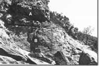
Location: | 000150. 30 kilometres south-east of Cann River. This is an extensive area and extends from Clinton Rocks to the Thurra River. |  Calcareous dune sandstone (A), overlying granite (B) - Point Hicks |
Abstract: | Granite headland and coastal plateau by a complex of Pleistocene and Holocene dunes with interdune lakes and swamps. | |
Access: | Point Hicks Road to the eastern part of the area and Clinton rocks track to the western part. | |
Ownership: | Crown Land (Croajingolong National Park) for most of the area apart from a small reserve of the Commonwealth land at the Point Hicks lighthouse. | |
Geology: | Upper Ordovician sandstones and slates outcrop at the mouth of the Thurra River and in small embayment west of the Point Hicks Lighthouse where they are tightly folded. Point Hicks is a headland of the Bega Batholith granite with prominent sandstone inclusions and minor aplite dykes. Weathered granite outcrops at several places in the channel or the Thurra river. The granite is overlain by Pleistocene consolidated calcareous dunes (up to 60% carbonate), the contact being well exposed in a coastal cliff east of the lighthouse and in a gully on the north-eastern side of Point hicks. This well bedded dune sandstone also outcrops at several places in dune swales north of Point Hicks. Above the calcareous dunes are quartzose sands (averaging 4% carbonate), arranged as long vegetated parabolic dune ridges, but including large tracts of active dunes. | |
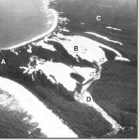
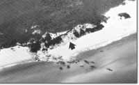
Geomorphology:  Point Hicks. Cliff-top dunes (A). Transverse dunes (B). Braided channel of Thurra River (C). Parabolic dune ridges (D), Sand spilling into Thurra River (arrowed) | The coast of Point Hicks is one of granite cliffs and bluffs in front of which are platforms and steep ramps intersected by narrow gutters eroded along joint planes. The bare rocks zone averages 30 to 50 metres wide and beaches, where present, are narrow and include boulders and broken material. Of major interest at Point Hicks is the complex of dune sands that overlie the Palaeozoic rocks and extend from Clinton Rocks to the Thurra River. The dunes cover and area of approximately 20 square kilometres and are notable for the wide range of dune types and the dimensions of both active and stabilised den ridges. Remnants of consolidated calcareous dunes are particular importance as they appear to be the most easterly occurrence of such materials on the Victorian coast. The stratigraphy of the calcareous and quartzose dunes had not been studied in detail but the Point hicks area provides the most complete sequence of Pleistocene dune sedimentation east of Wilsons Promontory. At least four main phases of aeolian sedimentation are represented here. The earlier phases are recorded by the presence of the lithified calcareous material at Point hicks and by remnants of ridges and dune swales and swamps further inland. Later stages are shown by the remarkable palaeosols exposed above Clinton Rocks, and near the Thurra River, and by the remarkable long, high vegetated sand ridges that dominate the physiography of much of the Point hicks area. These converging ridges comprise elongated parabolic dunes up to 4 kilometres long with deep intervening troughs or swales inside which are nested similar, but small, structures. Extensive areas if unvegetated mobile sand are arranged into transverse ridges oriented north-south at right angles to the prevailing westerly winds. These ridges are migrating down-wind and in several places are spilling into the Thurra River so that the lower course of the river displays a wise braided sand filled channel. Earlier episodes of dune activity have blocked and diverted the Thurra River and lead to the formation of small lake and more extensive swamp area upstream of the main sand ridge area. Several other small lakes and swamps occur in dune swales and in places where the dunes have blocked small streams. | |
Significance: | State. The importance of dune stratigraphy is referred to above. The area provides a major laboratory for the study of past and present processes of dune development. | |
Management: | The area is subject to rapid change so the location of visitor access and other facilities must recognise this. The dune mobility is not a dangerous or sinister element to be combated by stabilisation programmes as dune activity pre-dates European settlement and almost certainly pre-dates Aboriginal occupance of the area. Of major importance is the need to educate visitors to appreciate the sensitivity of dune vegetation and to reduce the risk of accidental fires. | |
 Sites 8722 4, 5, 6 |  Clinton Rocks. Lithified quartzose dunes with palaeosols (arrowed) |


