8622-9 Snowy River Islands
8622 7-14 (part 8522) - Snowy River Estuary and Floodplain
Page top
This information has been developed from the publications:
|
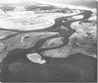
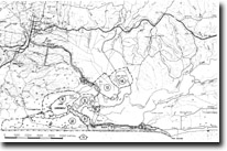
Location: | 340157 to 322170. Snowy River channel between Marlo and Lake Corringle. |  Snowy river delta and islands. |
Abstract: | Islands of compound origin in lower Snowy River. | |
Access: | Boat from Marlo. | |
Ownership: | Crown Land. | |
Geology/Geomorphology: | Two large swampy islands lie in the tidal channel connecting Lake Corringle to the Snowy River and two (First and Second Islands) lie in the wide river channel below this confluence. These islands are shaped by erosion and deposition due to river and tidal currents and display differing patterns of erosion and accretion. The largest island (First Island), the most southerly, is elongated and tapers at both ends with parallel accretion ridges prominent along the southern end. Eroded, undercut banks occur on the northern bank of First Island and on most of Second Island. Second Island is of interest in that it supports a dense stand of depauperate rainforset. First and Second Islands and the larger Corringle Channel island may be remnants of the Snowy River floodplain now isolated due to changes in the river channel. All islands are in part due to channel sedimentation and are shaped both by river and tidal currents. | |
Significance: | Regional. These are no true tidal delta islands and their mode of origin is not clear. The rainforest on Second island is of special interest. | |
Management: | No facilities that would encourage greater access to the islands are necessary as this would lead to deterioration of interesting aspects of geomorphology and ecology. | |


