8622-4 Point Ricardo - Cape Conran Dune Ridges
|
This information has been developed from the publications:
|
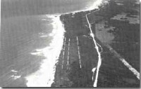
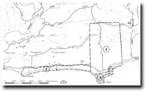
Location: | 470150. Coastline between Point Ricardo and Cape Conran, 12 kilometres east of Marlo. |  Parallel dune ridges (dotted) - Point Ricardo. |
Abstract: | Parallel dune ridges and coastal bluff. | |
Access: | Marlo – Cape Conran Road. | |
Ownership: | Crown Land. | |
Geology/Geomorphology: | The coast road to Cape Conran follows the approximate line of a low coastal bluff cut in consolidated Pleistocene dunes which are exposed in shallow road cuttings. Seaward of the bluff are several parallel dune ridges that are more or less continuous between Point Ricardo and Cape Conran. The ridges averae 10 to 12 metres high and have distinct and regular crests that have been very little modified by blowouts and are vegetated by dense Letosperum laevicatum scrub. | |
Significance: | Regional. The parallel ridges are the best development features of this type east of Lakes Entrance and represent an unusual prograded sandy shoreline sector. | |
Management: | Beach access roads and footpaths should be confined to the eastern and western ends of this coastal sector to reduce the risk of initiating blowout formations on the sandy ridges. | |
References: | Rosengren, N. J. 1978. The Physiography of Coastal Dunes, East Gippsland, Victoria. M. A. Thesis (Unpub.), University of Melbourne | |
 Sites 8622 4 5 6 |


