8622-3 Yeerung River
|
This information has been developed from the publications:
|
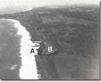
Location: | 565160. 3 kilometres east of Cape Conran. |  Double barrier at Yeerung River entrance. Outer barrier (A). Inner Barrier (B). |
Abstract: | Inliers of Palaeozoic rock beneath Tertiary and Quaternary sands. Small barriers and coastal lagoon. | |
Access: | Unformed road from Cape Conran and Old Coast Road. | |
Ownership: | Crown Land. | |
Geology: | Palaeozoic metasediments and granitic rocks are exposed at several points along the Yeerung River downstream from the crossing of the Old Coast Road. Coarse sands, minor gravels and clays overlie the Palaeozoic topography marked by low ridges and swampy depressions. | |
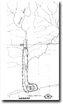
Geomorphology: | A narrow, well defined valley with small rapids in the stream channel marks the sections of the Yeerung River where the Tertiary sediments have been eroded to expose the Palaeozoic rocks. Below the junction of the East and West Branches the river follows a straight course that is not influenced by the older dune topography.
The tidal lagoon of the Yeerung has a pronounced meander where it has been deflected initially to the east, by a small inner barrier and subsequently to the west, by the emplacement of a younger outer barrier. | |
Significance:: | Local. River dissection demonstrates the thickness of the Tertiary and Quaternary sediments. | |
Management: | Maintenance of the Old Coast Road is necessary to allow access to the valley sections in Palaeozoic rocks. | |


