8622-14 Lake Curlip
8622 7-14 (part 8522) - Snowy River Estuary and Floodplain
Page top
This information has been developed from the publications:
|
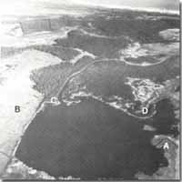
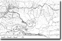
Location: | 380205. Three kilometres east of Snowy River near Tabberabbera. |  Lake Curlip. Abandoned river delta (A). Bluff (B). Active tidal delta (C). Abandoned crevasse delta (D). |
Abstract: | Brackish tidal lagoon and adjacent swamps. | |
Access: | Boat via Brodribb River from Marlo. Mt. Raymond Tower Road. | |
Ownership: | Crown Land, surrounded by private land. | |
Geology: | East of Lake Curlip is a low bluff exposing recrystallized granite overlain by Tertiary sediments. The lake is fringed by swampland, the floor and shoreline consist of organic muds and sands. | |
Geomorphology: | Lake Curlip is part of an extensive wetland that occupies the south-eastern section of the Snowy River floodplain. This low lying area is a flood basin of the Snowy fed also by the Brodribb River and Cabbage Tree Creek and containing a broad area of reedswamp and swamp scrub. The bluff that defines the eastern margins of the flood plain and Lake Curlip follows the alignment of the Brodribb Fault. In part it has been developed by wave action when the lake was deeper and depths now are generally less than one metre. Lake Curlip is connected to the Snowy River by the lower Brodribb channel and at times receive tidal inflow so the water in the southern part of the lake is often brackish. Three deltas protrude into the lake, the largest being an abandoned flood crevasse channel from the Snowy River now filled by reed and ti-tree swamp Smaller and actively growing deltas occur at the mouth of the now diverted Brodribb River on the western side of the lake and at the point of tidal inflow from the Lower Brodribb channel. | |
Significance: | Regional. The bluff and the entire wetland record a major stage in the evolution of the Snowy and Brodribb Rivers. Of particular interest are the deltas in Lake Curlip and the stratigraphy of the lake floor deposits. | |
Management: | Further drainage, diversion or land reclamation works which directly modify the lake and swamp and/or alter the flow regime into and out of the lake will reduce the scientific interest of the site and should be prohibited. | |


