8622-11 Snowy River - Brodribb River Confluence
8622 7-14 (part 8522) - Snowy River Estuary and Floodplain
Page top
This information has been developed from the publications:
|
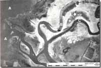
Location: | 340173. 3 kilometres north-west of Marlo. |  Lake Corringle (A). Snowy river (B)/Brodribb River (C) confluence. Arrow indicates site of future cut-off (Source: RAAF, 1941). |
Abstract: | Meanders, flood plain deposits. | |
Access: | Boat in Snowy River. | |
Ownership: | Private Island. | |
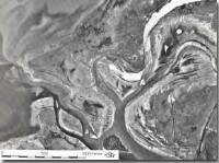
Geology/Geomorphology: | Below Orbost, the Snowy River channel is relatively straight with meanders of small amplitude and long wave length. Near the confluence of the Brodribb River the channel is more sinuous and meanders of both rivers have low point bar ridges of coarse sand on the inside of the meander bends. A tight meander on the Snowy near the confluence with the Brodribb was breached by flooding in 1964 and the upstream end of the new cut-off is now blocked by sand and silt. The downstream end of the meander is open to flood tidal inflow from the Snowy estuary and is becoming a more saline lagoon as it receives fresh water inflow. | |
Significance: | Local. The formation of a cut-off meander is unusual in the general development of the Snowy River flood plain. This is an interesting site from the viewpoint of monitoring the rates and types of sediments accumulating in the abandoned river section. | |
Management: | Removal of sand from the new cut-off should be prohibited as this would reduce the value of the site for monitoring the rate of sedimentation. | |
 Lake Corringle, Snowy River/Brodribb River confluence. Note cut-off meander (A) on Snowy River. |  Sites 8622 7 to 16 |


