8524-16 Mt. Stradbroke - Rocky Range
|
This information has been developed from the publications:
|
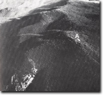
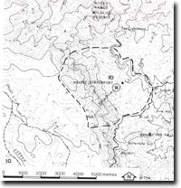
Location: | 140100. Four kilometres west of Suggan Buggan. |  Mount Stradbroke (A) and Rocky Range, marking the edge of the Wulgumerang Tableland and High Plain. |
Abstract: | Erosion escarpment on Snowy River’s Volcanics. | |
Access: | Walk from Block Mountain Road. | |
Ownership: | Crown Land. | |
Geology/Geomorphology: | The eastern edge of the major block of Snowy River Volcanics which extends as high plain and plateau south-east from Mount Cobberas, is marked by a long escarpment which displays precipitous cliffs at, and south from, Rhyodacite and rise 300 to 400 metres above the valley of the Suggan Buggan River, which is here eroded in Lower Palaeozoic granitic rocks. | |
Significance: | Regional. The escarpment provides an extensive exposure of Snowy River Volcanics, and marks the edge of one of the major terrain units of north-east Gippsland, ie. The Cobberas-Wulgulmerang High Plains and Plateau. | |
Management: | Because of the area covered by the site, the value of the significant geological and geomorphological features is unlikely to be seriously reduced by localised land disturbance. | |

8524-16


