8524-11 Cleft Peak
|
This information has been developed from the publications:
|
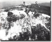
Location: | 032208. North of Middle Peak and Mount Cobberas No. 1. |  Mount Cobberas. Amphitheatre and vegetated periglacial rock rivers, (A). Cleft peak (B). Middle Peak (C). Mount Cobberas No. 1 (D). |
Abstract: | Twin peaks of rhyodacite | |
Access: | Walk from The Playground | |
Ownership: | Crown Land | |
Geology/Geomorphology: | Cleft Peak is a spectacular formation consisting of two rock pinnacles separated by a bowl-shaped hollow. The cliff faces are determined by joint planes in the Snowy River Volcanics- these cliffs being the highest in the Cobberas area. Small, fresh talus slopes occur at the cliff foot by the amount of material involved is small compared with the large, relict, block streams on the adjacent slopes. | |
Significance: | State. The extensive outcrops and the configuration of the mountain summit produce one of the most rugged mountain landscapes in Eastern Victoria. | |
Management: | Roads, transmission lines, mining or other earthmoving projects would be discordant with the geomorphologically significant patterns of the Cobberas area and should not be permitted. | |


